
Shinagawa_Station_Area.jpg
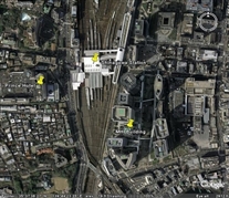
Tokyo -- Shinagaws Station (from Google Earth)
This image focuses on Shinagawa Station. The linear features above (north of) and below (south of) the train station are tracks and platforms. The shinkansen uses the rightmost (most eastern) tracks -- the loading platform for the shinkansen seemed to be the only platform that was enclosed.
The Prince Hotel "pin" points at the tower we stayed in. For scale, the Price Hotel tower and the MHI building are about 0.3 miles apart (crow flight). We had to go between them by walking thru Shinagawa Station, which was probably at least double that distance. We walked thru at rush hour, when the station was quite crowded (with people getting off of trains or going toward the entrances to the train area, in addition to people like us using it as a bridge across the rail tracks). Walking thru the station was like moving thru a river of men (and some women) -- all wearing black suits.
If you want to look at this area with Google Earth or one of the satelite map web sites (more useful -- and more fun -- than this "captured" image), Shinagawa Station is at about 35 deg, 39 min North and 139 deg, 44 min, 20 sec East.
The hotel where John and I stayed the first time in Tokyo is near Osaki Station, perhaps 2 miles southwest of Shinagawa Station (it is at about 35 deg, 37 min, 12 sec North and 139 deg, 43 min, 40 sec East). When I looked at that area using Google Earth around early 2009, it looked to me like the satellite photo they have for that area was taken when that hotel and the adjacent Thinkpark Tower were still under construction.
(Shinagawa_Station_Area.jpg)
