A-04-Argentina-001A.jpg
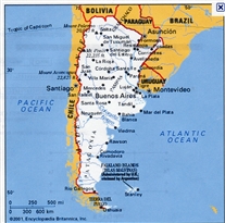
Overview Map of South American
This is just to provide a general overview orientation for the South America portion of the trip.

IMG_0015.jpg
Jacaranda in bloom -- Buenos Aires, Argentina
This was in a small city park near the hotel. November is spring in the Southern Hemisphere.
(17 Nov 2010)
After I had pretty much finished adding these descriptions in Feb 2013, I realized that I had created a number of descriptons a year or rmore ago, during an earlier try at findng a way to display these photos. I went thru and copied some of those earlier descriptions at the end of what I had created in early 2013 (below the inserted dates, when those dates are in the descriptions). There may be some repetition between the early-2013 material and this inserted-at-the-end material, However, I wanted to spend minimal time editing (merging the two comments to make them read smoothly). These add-on descripitons are pretty much all for the first 5 or 6 days of the trip (that was apparently as far as I got in the some-time-ago first cut at writing descriptions.
The first such add-on description follows:
Trip started on 16 Nov with an overnight flight from Atlanta to Buenos Aires, arriving there the morning of 17 Nov. Was pretty tired that day, but went on a short walking tour of the area around the hotel. These are Jacaranda trees – November is spring in the southern hermisphere.
Shutter Speed : 1/158.68
Date Time : 2010:11:16 15:14:19�
Equip Model : Canon PowerShot A495�
ISO Speed : ISO-80
Focal Length : 14.8
Aperture : F/4.5

A-IMG_0042.jpg
The Structure Formerly Known as The English Tower
Buenos Aires, Argentina.
The story seems to be that this tower was a gift from the British residents of Buenos Aires to the people of Argentina to mark the 100th anniversey of Argentine independence. The gift was announced around 1909-1901, but the tower was not fully completed until around 1915 or 1916. I'm not sure of the name in Spanish, but can be translated as (roughly) "The English Tower".
After the 1982 war, the tower was renamed. I'm also unsure of the current name in Spanish, but it can be translated (roughly) as Monument Tower.
(probably 17 Nov 2010)

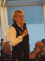
IMG_0020A.jpg
Valerie Martin, Vantage Program Manager
Valerie was extremely hard-working, flooding us with information about the places we were visiting -- and this was over and above the large amount of information the ship provided (in writing and in lectures) once the cruise segment began. Also, Valerie was always bright, perky, and enthuastic -- a pleasure to be around.
(17 Nov 2010)
Trip was an escorted tour with Vantage Travel (Agency). This is Valerie Martin, the Vantage “Program Manager” (the tour escort).
Somewhat south of the building we were in when this photo was taken is a tower given to Argentina by Great Britain around 1910, for the centennial of Argentina’s independence. For many years it was called the British Tower. After the war with Britain over the Malvinas (or Falkland Islands), the tower was converted to a memorial for Angentinans killed in that war. The tower has been renamed something like Memorial Tower.
Shutter Speed : 1/12.91
Date Time : 2010:11:16 15:35:00�
Equip Model : Canon PowerShot A495�
ISO Speed : ISO-800
Focal Length : 21.6
Aperture : F/5.78

IMG_0026A.jpg
Plaza Near Presidental Palace
Buenos Aires, Argentina. This is a scene for political demonstrations. I did not photograph it, but right across the street was a sort of camp-in by veterans of the 1982 war with the United Kingdom, where they were demanding increased benefits.
(18 Nov 2010)
Next day, on a tour of the city by bus (well, tour of part of the city – it’s gigantic), and after a much-needed night’s sleep.
This plaza is in front of a building called Casa Rosada, which seems to be the “traditional” presidential palace, but is really now the presidential office building (her residence is north of dowtown – the president in office in 2010 was a woman; apparently Brazil and Chile have also had women presidents).
The cloth banner is related to a protest that had been in progress for some weeks dealing with improved pensions for Malvinas War veterans.
Shutter Speed : 1/404.5
Date Time : 2010:11:17 07:41:49�
Equip Model : Canon PowerShot A495�
ISO Speed : ISO-80
Focal Length : 6.6
Aperture : F/2.99

IMG_0032A.jpg
Presidential Palace (called the Pink Palace)
Buenos Aires. Argentina. The tree windows on the left-hand side (with closed shutters on them) are where Eva Perone (and her husband, Juan, the president) would address crowds in the plaza. The scene where Madonna sings "Don't Cry for me Argentina," in the movie version of "Evita" was also filmed here (they gave the film crew access for only a few hours late one night). Although called a palace, it is really an office building now, the president has a residential compound elsewhere in the city. I think even at the time of Juan and Eva Perone, the building was no longer a residence.
(18 Nov 2010)
This is Casa Rosada. It is made of stone that has a slight pinkish cast, but that’s not really visible here. This side of the building was in shadow when we were there.
The three windows on the left-hand side of the second floor are where the president gives public addresses – and where Eva Perone gave at least one famous speech – and where Madonna doing the “Don’t Cry For Me, Argentina” song was filmed for the movie “Evita.”
Date on the photo is incorrect. In January 2010, I realized I’d goofed when I gone thru the setup process after this camera was purchased in early November. [Added to this end-of-description "adder"in Feb 2013 -- the incorrect date is on the image itself (and on other images). This does not refer to the date in this description, above).]
Shutter Speed : 1/202.25
Date Time : 2010:11:17 07:43:53�
Equip Model : Canon PowerShot A495�
ISO Speed : ISO-80
Focal Length : 21.6
Aperture : F/5.78

IMG_0043.jpg
Recoleta Cemetery
Buenos Aires. Argentina. Eva Perone is interred here. This cemetery contains about 5000 of these small private mausoleums, and no ordinary graves. The cemetery is full. People who want to be buried there now have to buy out one of the current occupants. Recoleta is also apparently the name of the district of the city where this is located.
(18 Nov 2010)
This is a downtown cemetery where Eva Perone is buried. There seem to be no “single” graves here. It is all small private (family) masaleoums – around 5000 of them.
The times printed on some of these photos correspond to US Eastern Standard Time (UT-5) – the clock in the camera was never reset. Argentina operates on UT-3. Thus, when the US East Coast was at 10:16 (am), as shown here, the actual local time in Argentina was 12:16 pm. The cruise ship to Antarctica operated on Argentina time during the entire trip. However, once we got to Antarctica, it never really got dark at “night” so accurate local times were not critical.
Shutter Speed : 1/404.5
Date Time : 2010:11:17 10:16:16�
Equip Model : Canon PowerShot A495�
ISO Speed : ISO-80
Focal Length : 6.6
Aperture : F/2.99

IMG_0048.jpg
Eva Perone Interment Site
Buenos Aires. Argentina. She was interred here around1974, over 20 years after her death. Her body had an interesting journey post-life (in part, due to Argentine politics, coups, etc.). Duarte is her father's surname (and apparently hers for a time -- she was one of five children born to her father's mistress; he had another family by his legal wife). It wasn't clear how many years she actually used her father's surname prior to her marriage.
(18 Nov 2010)
This is the mausoleum where Eva Perone was finally interred, more than 20 years after her death (her embalmed body had quite an adventure, which I don’t have time or space to describe here). Duarate is her father’s name, which she did not use as a child. She was one of several children in a “second” (unacknowledged) family her father had by a servant. I imagine once her husband became president, she could use any name she wanted.
The date on this photo (and several others) seems to be at a bit of an angle. I’ve had some problems holding this camera parallel with the ground. This was corrected with a photo editing program, but that leaves the date at a bit of an angle.
Shutter Speed : 1/404.5
Date Time : 2010:11:17 10:35:58�
Equip Model : Canon PowerShot A495�
ISO Speed : ISO-400
Focal Length : 6.6
Aperture : F/2.99
IMG_0052.jpg
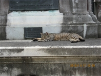
Live Resident of Recoleta Cemetery
Buenos Aires. Argentina.
(18 Nov 2010)
One of several cats who seemed to live in the cemetery.
Shutter Speed : 1/202.25
Date Time : 2010:11:17 10:39:26�
Equip Model : Canon PowerShot A495�
ISO Speed : ISO-80
Focal Length : 14.8
Aperture : F/4.5

IMG_0056A.jpg
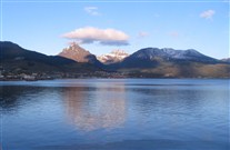
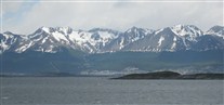
Ushuaia, Argentina
This was taken from the parking area in front of the airport.That's the town off in the distance at the base of the mountains. There were ski slopes/trails that just barely show up in this view (one is to the left of center, cut through the forest between the town and the tree line. However, I was told the lifts have been removed. There is a newer ski area a few miles away.
I cropped this photo to remove a number of foreground parked vehicles. You can still see the word "taxi" (which I missed) on the left at the bottom of the photo.
(19 Nov 2010)
Flew here on the morning of the 19th. It’s on the north shore of the Beagle Channel. This photo was taken from the airport, which is essentially right on the water.
Those mountains are pretty impressive. The plane seemed to apporach the airport by flying down the Beagle Channel for several miles. Both the surrounding and the architecture of the town gave the impression of a European alpine village.
Population is perhaps 40,000. It’s the southernmost city in the world anywhere near that size.
Shutter Speed : 1/1002.93
Date Time : 2010:11:18 11:53:01�
Equip Model : Canon PowerShot A495�
ISO Speed : ISO-80
Focal Length : 6.6
Aperture : F/4.5

IMG_0060A.jpg
Beagle Channel from Ushuaia Airport
Ushuaia, Argentina. This was taken from near where the previous photo was, but facing the opposite direction. The body of water is the Beagle Channel. Ushuaia is on the north shore of the Beagle Channel.
There were mountains in essentially every direction. The flight to Ushuaia had come from Buenos Aires, several hundred miles to the north. I think the pilot (flying south) had crossed the mountains (perhaps through a mountain pass) maybe 25 or 30 miles east of Ushuaia and them done the last part of his landing descent/approach flying west OVER the Beagle Channel.
(19 Nov 2010)
Another view from the airport. This time looking toward the Beagle Channel.
Shutter Speed : 1/1002.93
Date Time : 2010:11:18 11:53:36�
Equip Model : Canon PowerShot A495�
ISO Speed : ISO-80
Focal Length : 6.6
Aperture : F/4.5

IMG_0093.jpg
Tierra del Fuego National Park, Argentina
Near Ushuaia, Argentina. The southern tip of South America is really a series of island, with Tierra del Fuego being (probably) the largest one. TIerra del Fuego is separated from the mainland by the Strat of Magellan. The Beagle Channel is the southern boundary of that island.
Took a tour sponsored by either the ship or by Vantage, I forget) of this park. This was, in part, to "kill time" until the ship was ready for boarding.
Many of the sights in Ushuaia are along the lines of the southermost golf course in the world, the southernmost bowling alley in the world, the southernmost riding stable in the world, etc. All true, I' m sure, but they hardly need it with the great mountain scenery all around.
As best I could tell, the only town south of here is Port William, which is in Chile (on the opposite side of the Beagle Channel and maybe 35 miles east). Port William (which we were at later) is much smaller.
This sign is at the southern end of the "Transamerica Highway", Alaska (Fairbanks, I believe) is at the north end. I put the name in quotes because I don't think it "really" exists. It seems to be a designation they placed on a bunch of pre-existing roads in the various countries, and there are a few places (mostly in Central America) where the roads don't -- the highway is just a line marked on a map (at least, that's the impression I got).
(19 Nov 2010)
This is a national park a few miles out of town (to the west). Sign indicates this is the south end of the Transamerican Highway – the other end is in Fairbanks Alaska. However, stuff I learned later leads me to suspect there are some pretty substantial gaps, where the highway exists more as a line on a map than as a driveable “highway”.
Shutter Speed : 1/101.13
Date Time : 2010:11:18 13:50:49�
Equip Model : Canon PowerShot A495�
ISO Speed : ISO-80
Focal Length : 9.84
Aperture : F/3.51

IMG_0067A.jpg
Tierra del Fuego National Park, Argentina
The snow-capped mountains in the distance are in Chile. The border between the two countries border is confusing here. Apparently, you can't go by land from the southernmost point in Argentina to the capitol of Argentina (Buenos Aires) without passing thru part of Chile. Also, you can't go by land from the southernmost point of Chile to the capitol of Chile without passing thru Argentina. And, actually, you can't go by land at all, because you have to cross the Strait of Magellan (and probably the Beagle Channel). Neither of those waterways is bridged at any point, so far as I know.
(19 Nov 2010)
Inside the national park. The mountains in the distance are in Chile.
Shutter Speed : 1/317.37
Date Time : 2010:11:18 12:56:26�
Equip Model : Canon PowerShot A495�
ISO Speed : ISO-80
Focal Length : 21.6
Aperture : F/5.78

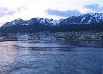
L-DSCF0101.jpg
Ushuaia
I believe this was taken from the bus on the way back from the National Park. I like the sky in this and the clouds reflected in the water.
(19 Nov 2010)
Shutter Speed : 1/181.02
Date Time : 2010:11:19 15:00:27�
Equip Model : FinePix F80EXR�
ISO Speed : ISO-100
Focal Length : 5
Aperture : F/8.88

IMG_0115.jpg
Ushuaia, Argentina
This was a sign I noticed on the dock near our cruise ship. Apparently many of the supplies to Argentine stations in the Antarctic come thru here.
(19 Nov 2010)
Near the dock on the way to the ship. Argentina has several small stations in Antarctica. Apparently a lot of their logistic support is from here.
Argentina has large land claims in Antarctica. To support this, they have a few hundred people living at their stations during Southern Hemisphere summer. I’m pretty sure they number who stay over during winter is much smaller.
Argentina, Britain, and Chile have overlapping land claims. There is a treaty that essentially puts all claims on hold for the indefinite future, but they have not been abandoned
Shutter Speed : 1/202.25
Date Time : 2010:11:18 15:05:01�
Equip Model : Canon PowerShot A495�
ISO Speed : ISO-80
Focal Length : 14.8
Aperture : F/4.5

IMG_0752AA.jpg
MS Fram
The Fram at the dock. Actually, this photo was taken at the end of the trip (and appears again later in the proper sequence. For various reasons, was not able to get a good photo of the exterior of the ship during boarding in Ushuaia. Since the "story" seemed to need a photo at this point, I used the closest thing I had.
Shutter Speed : 1/317.37
Date Time : 2010:12:02 07:03:38�
Equip Model : Canon PowerShot A495�
ISO Speed : ISO-80
Focal Length : 17.55
Aperture : F/5.03

IMG_1524.jpg
Aboard MS Fram
Unknown to us in advance, had been upgraded to a suite at the stern of the ship -- and perhaps the best suite on the entire ship. Waited until the ship had sailed before unpacking, in case this cabin assingment had been a mistake. Room that was purchased was perhaps 1/3 this size (with one "picture" window and no balcony -- there were only perhaps 6 cabins with balconies on the entire ship).
This is the door to our cabin, which turned out to be a suite (and a fine one at that). We had been upgraded and didn’t know it beforehand (and didn’t quite believe it for a while – kept expecting someone would knock on the door and say it was all a mistake). Only the suites had names (this one was named for a polar explorer) and these fancy brass door plates.
Ship seemed to be designated MV Fram in some places. Never understood the difference.
On the ship here, but it’s still at the dock in Ushuaia.
Shutter Speed : 1/60.13
Date Time : 2010:11:19 18:39:14�
Equip Model : Canon PowerShot S1 IS�
Focal Length : 5.8
Aperture : F/2.8

IMG_1525.jpg
Aboard MS Fram (Cabin/Suite 541 Interior)
Shutter Speed : 1/60.13
Date Time : 2010:11:19 18:39:20�
Equip Model : Canon PowerShot S1 IS�
Focal Length : 5.8
Aperture : F/2.8

IMG_1527.jpg
Aboard MS Fram (Cabin/Suite 541 Interior)
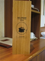
Note the wooden box on the left side of the dresser/desk. It shows up in later photos.
Shutter Speed : 1/60.13
Date Time : 2010:11:19 18:40:18�
Equip Model : Canon PowerShot S1 IS�
Focal Length : 5.8
Aperture : F/2.8

IMG_1538A.jpg
Aboard MS Fram (Cabin/Suite 541 Interior)
This is looking out from on the balcony while still at the dock in Ushuaia.
(19 Nov 2010)
Shutter Speed : 1/101.13
Date Time : 2010:11:19 18:47:05�
Equip Model : Canon PowerShot S1 IS�
Focal Length : 5.8
Aperture : F/4.5
IMG_1539.jpg
Aboard MS Fram (Cabin/Suite 541 Interior)
This is looking out from the balcony while still at the dock in Ushuaia (opposite direction from previous photo). These seems to be only one dock, which handles both freighters and passenger ships. That is a container ship docked at the other side of the pier.
(19 Nov 2010)
Shutter Speed : 1/60.13
Date Time : 2010:11:19 18:47:17�
Equip Model : Canon PowerShot S1 IS�
Focal Length : 5.8
Aperture : F/4

IMG_0750.jpg
Aboard MS Fram (Exterior of Cabin/Suite 541 Door)
The suites had names in addition to cabin numbers. AlsoI believe it was only the suites that had these little medallions on the doors. The first clue to the upgrade had been just after I received the key to Cabin 541. Looked at the sign at the entrance to the corridor and saw the highest cabin number listed was 539. Had a bad feeling there had been a goof-up and my assigned cabin did not really exist. What came to pass was a MUCH more pleasant kind of surprise.
This is the door to our cabin, which turned out to be a suite (and a fine one at that). We had been upgraded and didn’t know it beforehand (and didn’t quite believe it for a while – kept expecting someone would knock on the door and say it was all a mistake). Only the suites had names (this one was named for a polar explorer) and these fancy brass door plates.
Ship seemed to be designated MV Fram in some places. Never understood the difference.
On the ship here, but it’s still at the dock in Ushuaia.
Shutter Speed : 1/50.56
Date Time : 2010:12:02 06:17:57�
Equip Model : Canon PowerShot A495�
ISO Speed : ISO-500
Focal Length : 6.6
Aperture : F/2.99

IMG_1541A.jpg
Aboard MS Fram (Cabin/Suite 541 Interior)
There was a plaque inside the cabin telling about the person the suite was named for.
Shutter Speed : 1/60.13
Date Time : 2010:11:19 18:58:50�
Equip Model : Canon PowerShot S1 IS�
Focal Length : 9.97
Aperture : F/3.08
IMG_0704.jpg
Aboard MS Fram (Cabin/Suite 541 Interior)
The wooden box contained a commerative bottle of liquor, special-made (supposedly), individually numbered, etc. For various reasons, it was left behind. However, took photos to capture the thought.
Memory is that this was the national drink of Norway (aqua vita) and this batch had been made for the shipping line from melted sea ice taken from both the Artic and Antarctic Oceans.
The reasons this was left behind included lack of space and available weight allowance in luggage. That was, in part, because I took too many clothes -- and the clothes I took were too bulky (principally heavy sweaters). Turned out it really was't extremely cold (there were a couple cold-seeming days because of wind, but it probably never got below around 18 F). Another reason I felt dumb about taking the sweaters was that they had some really nice "Norwegian-type" cable-knit sweaters for sale in the gift shop on the ship. I couldn't buy one (even if I wanted) due to lack of available luggage space and weight allowance.
Shutter Speed : 1/19.84
Date Time : 2010:12:01 19:19:38�
Equip Model : Canon PowerShot A495�
ISO Speed : ISO-640
Focal Length : 8.06
Aperture : F/3.18

IMG_0706.jpg
Aboard MS Fram (Cabin/Suite 541 Interior)
Story of ships named Fram posted inside box containing liquor. Fram was named after an older exploring ship named Fram
Shutter Speed : 1/25.28
Date Time : 2010:12:01 19:20:13�
Equip Model : Canon PowerShot A495�
ISO Speed : ISO-400
Focal Length : 8.06
Aperture : F/3.18

IMG_0705.jpg
Aboard MS Fram (Cabin/Suite 541 Interior)
Inside of box.
Shutter Speed : 1/19.84
Date Time : 2010:12:01 19:19:59�
Equip Model : Canon PowerShot A495�
ISO Speed : ISO-500
Focal Length : 8.06
Aperture : F/3.18
IMG_0708.jpg
Aboard MS Fram (Cabin/Suite 541 Interior)
Label on the whiskey. These "whiskey" photos were taken near the end of the trip, but I grouped with the rest of the cabin interior shots.
Shutter Speed : 1/19.84
Date Time : 2010:12:01 19:20:43�
Equip Model : Canon PowerShot A495�
ISO Speed : ISO-500
Focal Length : 8.06
Aperture : F/3.18
IMG_1530A.jpg
Views From Ushuaia, Argentina
Ship was still at dock at this point. This photo and the next several were taken from the ship.
(19 Nov 2010)
Shutter Speed : 1/317.37
Date Time : 2010:11:19 18:42:05�
Equip Model : Canon PowerShot S1 IS�
Focal Length : 5.8
Aperture : F/4.5
IMG_1547A.jpg
Views From Ushuaia, Argentina
I believe ship was pulling out of harbor when these were taken, I was fascinated by birds "swarming" around the water stirred up by the ship.
(19 Nov 2010)
Shutter Speed : 1/101.13
Date Time : 2010:11:19 19:03:25�
Equip Model : Canon PowerShot S1 IS�
Focal Length : 5.8
Aperture : F/4.5

IMG_1547B.jpg
Views From Ushuaia, Argentina
Birds. May have been expermenting with different zoom lens setting and different ways of cropping the images.
(19 Nov 2010)
Shutter Speed : 1/101.13
Date Time : 2010:11:19 19:03:25�
Equip Model : Canon PowerShot S1 IS�
Focal Length : 5.8
Aperture : F/4.5

IMG_1549A.jpg
Views From Ushuaia, Argentina
Birds. May have been expermenting with different zoom lens setting and different ways of cropping the images.
(19 Nov 2010)
Shutter Speed : 1/60.13
Date Time : 2010:11:19 19:03:37�
Equip Model : Canon PowerShot S1 IS�
Focal Length : 24.28
Aperture : F/3.51

S-IMG_8332.jpg
Views From Ushuaia, Argentina
This is cool with the moon in the photo, but look at the NEXT picture.
(19 Nov 2010)


IMG_1557A.jpg
Beagle Channel
Sailiing west in Beagle Channel from Ushuaia.
(19 Nov 2010)
Shutter Speed : 1/158.68
Date Time : 2010:11:19 19:06:48�
Equip Model : Canon PowerShot S1 IS�
Focal Length : 5.8
Aperture : F/4.5
A-IMG_0068.jpg
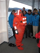
Passenger Lifeboat Drill
Because we would be cruising in VERY cold water, this ship's lifeboat, lifejacket drill had an extra wrinkle: the thermal protection suit. This is one of the ship's crew (a waiter) after havng demonstrated how to put it on. It seemed to be made of VERY thin plastic (and contained no thermal insulation).
They might provide protection if someone had to swim a short distance in Antarctic waters to reach a lifeboat. It seemed the idea was to keep you relatively dry (little or no direct contact with water), but not toasty warm,
(19 Nov 2010)
The lifeboat drill included a demonstration of putting on a “thermal suit” (as well as a life vest). The suit is thin plastic. It might keep one dry, but not warm. I’m guessing it might extend your life expectancy in Antarctic waters by maybe 25-30 minutes. Apparently the idea is that you would be pulled into a life boat or a life raft by then.
The person doing the demonstration is one of the dining room waiters.
Thanks to the Andersons for this photo.

S-IMG_8351.jpg
Emergency Drill on Fram
This is a crewman. In addition to the "lifeboat drill" (etc.) for passengers, they were doing crew proficency training for various emergency situations.
(19 Nov 2010)
Not sure if this was the same day as the passenger drill or if it was the next day. The ship’s crew had to do more extensive safety/casualty training. This is one of their training exercises. This is a crew member who is simulating being injured (perhaps not very convincingly).
Thanks to the Andersons for this photo
A-IMG_0071.jpg
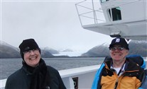
Karin Strand -- Expedtion Team Leader
This was during a passenger orientation session our first evening on the ship. Linda Wright and I are visible in the lower portion of this photo.
This was taken in what you might call the foreward observation lounge on Deck 7 (they sometimes refered to it as the passenger bridge, it's just above the "real" navigation bridge). This lounge was also the ship's bar (this ship essentially had only one bar, and no casino).
Karin is standing on the lounge's dance floor. Linda and I are sitting at tables at a slightly lower level. There are some photos of this bar later in this album.
(19 Nov 2010)
This is an orientation lecture the first night, after we were underway, sailing west in the Beagle Channel. This is Karin Strand, who is the head of what they call the expedition team (she’s like a cruise director, except it’s a more outdoorsey – and less social -- job that on a “normal” cruise ship – and probably a cooler job too).
Note Linda and I are in the background of this photo.
Thanks to the Andersons for this photo.

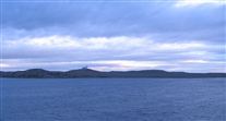
A-05-Cruise-01-001.jpg
Southern South America
First part of cruise was in what they call the Chilean Fjords, up to Pueroto Arenas, Chile, and then back to Peurto Williams, out the east end of the Beagle Channel, past Cape Horn, and south toward the Antarctic Pennisula.
The first part of the trip was called Crusing the Chilean Fjords (this was a Norwegian ship, so the word "fjords" remnds them of home, I guess).
There's a lot on this map. We sailed west from Ushuaia, then out the west end of the north branch of the Beagle Channel, they through several channels and straits (between high often-snow-covered mountains) to eventually enter the Strait of Magellan, docking at Punto Arenas, in Chile. After a day there, stopped at Magdelena Island. Then went south in the Whiteside Channel around the east side of Dawson Island, eventually getting back to re-trace our original course thru the Cockburn Channel (and other waterways) to essentialy sail the entire Beagle Channel (or, at the least the north branch of it). Backtracking through the Cockburn and Beagle Channels wasn't like a re-run because we had gone thru at ngiht the first time.
Some other things about this map: (1) Southern Chile is a very complicated jigsaw puzzle of odd-shaped, rugged mountain islands; (2) Cape Horn is NOT where I thought it was (it's an island south of what I think of as the:mainland" of South American, NOT -- as I had previously thought -- that "pointy" island on the extreme right-hand edge of this map); and (3) the red dot (which basically covers the island of Cape Horn on this map) is to mark a place where a landing was planed, but cancelled due to bad weather (which, in turn, caused high seas).
The word "mainland" is used (in quotes) above. However, having been there now, I'm not sure where "mainland South America" actually ends. There are a LOT of islands down there.
The following web site provides a somewhat better map of this region (without the Fram's couse marked on it): http://en.wikipedia.org/wiki/File:Chile.estrechodemagallanes.png.

IMG_0137A.jpg
Crusing Chilean Fjords
Somewhere in the region of the Cockburn Channel and Strait of Magellan.
(Probably 20 Nov 2010)
Aboard MS Fram
In Chilean fiords (or fjords) on the way to Punto Arenas Chile
Don’t remember what the name of this glacier was.
Shutter Speed : 1/317.37
Date Time : 2010:11:19 11:15:32�
Equip Model : Canon PowerShot A495�
ISO Speed : ISO-80
Focal Length : 14.8
Aperture : F/4.5

IMG_0143.jpg
Crusing Chilean Fjords
Somewhere in the region of the Cockburn Channel and Strait of Magellan.
Wish I had spend some effort cropping this one a bit. If you look closely at the shoreline (past the bow of the ship), you will see it is slanting upward, slightly toward the left. Thus the ship is heeled over to the left even more that is appears to be in this photo.
Don't recall exactly what was going on here. I THINK we were had a steady high wind coming from the right (the photographer's right), causing the ship to heel over, somewhat like a sailboat. However, it could be that some kind of rocking motion was going on, or (possibly) we could have been turning.
(Probably 20 Nov 2010)
In Chilean fiords (or fjords) on the way to Punto Arenas Chile
This is looking out toward the front (bow or prow) of the ship. The squarish thing just to left of center of this photo is the ship’s spare anchor (and the restraining device it lives in).
If you look closely at the angle between the horizon and the deck, you can see the ship was rockin’ pretty good when this photo was taken (and this was mild compared to sea conditions in the Drake Passage a few days later).
Shutter Speed : 1/809
Date Time : 2010:11:19 11:19:40�
Equip Model : Canon PowerShot A495�
ISO Speed : ISO-80
Focal Length : 6.6
Aperture : F/2.99

IMG_0156.jpg
Crusing Chilean Fjords
Somewhere in the region of the Cockburn Channel and Strait of Magellan.
(Probably 20 Nov 2010)
Shutter Speed : 1/404.5
Date Time : 2010:11:19 15:53:27�
Equip Model : Canon PowerShot A495�
ISO Speed : ISO-80
Focal Length : 9.84
Aperture : F/3.51
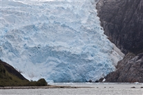
L-DSCF0125A.jpg
Glacier, Beagle Channel
Beagle Channel (or perhaps north, on the way to the Strait of Magellan), Chile. I'm not sure which galcier this is.
These two people were apparently out on deck, waiting for the goofy hat contest to start, when the ship passed this fine-looking glacier.
(20 Nov 2010)
Shutter Speed : 1/209.38
Date Time : 2010:11:20 11:17:01�
Equip Model : FinePix F80EXR�
ISO Speed : ISO-400
Focal Length : 5
Aperture : F/8.88

IMG_0159.jpg
MS Fram and US Antarctic Supply Ship
Punta Arenas, Chile. The hull of the supply ship seemed to be designed to give it at least some icebreaker-type capability. There were actually two such ships at this dock, both of which seemed to have icebreaker-type hulls, perhaps one moreso than the other. Was surprised to see US ships here, since I thought most of the US bases on the coast of Antarctica were on the "other" side, where they would be supplied from Australia and/or New Zealand.
There were also to Chilean naval gunboats at this dock, which I did not photograph. The gunboats had gray hulls. We later saw a coast guard vessel, which had white hull, I think these were likely navy.
My memory is that there was another dock, in a different part of town. A cruise ship (Holland American, I think) was docked there.
(21 Nov 2010)
This is the dock in Punto Arenas. Fram is on the left. A ship on the right-hand side is apparently a supply ship for US Antarctic bases. There were two such ships docked there. The both seemed to have ice-breaking capability. I don’t fully understand how the US supply system works, since (I think) most, but not all, US bases are closer to Australia than to South America. At least one of these ships listed New Orleans as its home port.
Shutter Speed : 1/809
Date Time : 2010:11:20 08:17:09�
Equip Model : Canon PowerShot A495�
ISO Speed : ISO-80
Focal Length : 6.6
Aperture : F/4.5
IMG_0170A.jpg
Insignia on US Antarctic Supply Ship
Punta Arenas, Chile.
(21 Nov 2010)
Sign on the side of the superstructure of one of the ships. The lower sign is apparently an emblem of the US Antarctic program
Shutter Speed : 1/1243.34
Date Time : 2010:11:20 09:27:02�
Equip Model : Canon PowerShot A495�
ISO Speed : ISO-80
Focal Length : 6.6
Aperture : F/4.5

IMG_0173.jpg
Stern of MS Fram
Punta Arenas, Chile. The area with the row of windows that curvesl around is the main dining room on Deck 4. The rightmost square window on Deck 5 (the next deck up) is in Cabin/Suite 541. The "window" partially visible to the right of that square widow is a glass "wind screen" on the side the balcony for Cabin/Suite 541.
(21 Nov 2010)
Stern of the Fram. Widows that are visible are on Decks 3, 4, 5, and 6 (Deck 3 in red area, other decks in white area). The sternmost Deck 5 “window” is really the end of our balcony. The Deck 5 window just to the left of that is in our cabin.
Shutter Speed : 1/1243.34
Date Time : 2010:11:20 09:30:11�
Equip Model : Canon PowerShot A495�
ISO Speed : ISO-80
Focal Length : 6.6
Aperture : F/2.99

L-DSCF0132.jpg
Landward End of the Dock
Punto Arenas, Chile
(21 Nov 2010)
Shutter Speed : 1/685.02
Date Time : 2010:11:21 08:20:15�
Equip Model : FinePix F80EXR�
ISO Speed : ISO-200
Focal Length : 5
Aperture : F/8.88

IMG_0164A.jpg
Statue of Bernardo O'Higgens (Liberator of Chile)
Punta Arenas, Chile.
(21 Nov 2010)
Punto Arenas
Walking into town. This is a statue of Berbardo O’Higgins. He is known the liberator of Chile (his father was born in Ireland).
Not sure what the well-groomed trees are called, but there were many of them, all over town.
Shutter Speed : 1/1002.93
Date Time : 2010:11:20 08:30:02�
Equip Model : Canon PowerShot A495�
ISO Speed : ISO-80
Focal Length : 6.6
Aperture : F/2.99

IMG_0164B.jpg
Statue of Bernardo O'Higgens (Liberator of Chile)
Punta Arenas, Chile. Cropped to give close-up of inscription at base.
(21 Nov 2010)
Shutter Speed : 1/1002.93
Date Time : 2010:11:20 08:30:02�
Equip Model : Canon PowerShot A495�
ISO Speed : ISO-80
Focal Length : 6.6
Aperture : F/2.99

IMG_0165.jpg
Statue of Magellan
Punta Arenas, Chile. This is in the main town square. Bob Anderson is holding a foot of one of the Native South Americans that are on the statue. A photo similar to this is also on his web site. Apparently he and Jan were here taking photos at the same this this photo was taken.
(21 Nov 2010)
Punto Arenas
Statue of Magellen in the Punto Arenas town square. Difficult to see here, but the statue contains several other figures, including a representation of one of his ships.
Punto Arenas is on the Strait of Magellen.
Shutter Speed : 1/501.46
Date Time : 2010:11:20 08:55:58�
Equip Model : Canon PowerShot A495�
ISO Speed : ISO-80
Focal Length : 9.84
Aperture : F/3.51

IMG_0166A.jpg
Sleeping Dogs in City Park
Punta Arenas, Chile. In town square, There are perhaps 20 carvel-like kiosks of this type in the town squanre. There had been several foot races (5K, 10K, etc.) in town that morning. Possibly because of the crowds at this event, all of the kiosks seemed to be open and in use. I have no way of knowing what a "normal" Sunday is like here, of course.
Have now seen seemingly well-fed (and possibly well-cared for) dogs like this, who appeared to be runniing free (well.maybe not running, but "napping free") in several places in South America. Not sure if they are strays (ot "town dogs," or if they are let out to roam during the day and go back to their homes at night. The dogs were all well-behaved.
(21 Nov 2010)
Punto Arenas
Town Square. There were several caravan (or “gypsy- wagon”-shaped) kiosks like this in the square. They were shops for souviners and craft items.
Street dogs like this were pretty common. All seemed very well-behaved – and most were quite clean
Shutter Speed : 1/634.73
Date Time : 2010:11:20 08:59:13�
Equip Model : Canon PowerShot A495�
ISO Speed : ISO-80
Focal Length : 12.05
Aperture : F/4

IMG_1560A.jpg
Rhea
Near Punta Arenas, Chile. This is at a nature preserve on Seno Otway, or Otway Sound.
I'm PRETTY sure this ostrich-like bird is called a Rhea.
(21 Nov 2010)
Punto Arenas
This was on a bus tour out of town to Otway Sound. I think this is bird is a rhea. (or possibly an emu – both names seemed to be used by the guides, but my understanding is that emu is Australian – right hemisphere anyhow).
Shutter Speed : 1/317.37
Date Time : 2010:11:21 13:29:54�
Equip Model : Canon PowerShot S1 IS�
Focal Length : 58
Aperture : F/4.5

IMG_1566A.jpg
Magellanic Penguin
Near Punta Arenas, Chile. This is at a nature preserve on Seno Otway, or Otway Sound. Took an extra-cost excurion from the ship out to this place to see about 35 penguins (the first ones we had seen) and some other wildlife. The excursion was fully booked with people from the ship. It was OK, but paying to see those 35-or-so penguins seemed pretty silly when we say a literal mountain of Magellanic Penguins the next day.
(21 Nov 2010)
Shutter Speed : 1/634.73
Date Time : 2010:11:21 14:02:12�
Equip Model : Canon PowerShot S1 IS�
Focal Length : 58
Aperture : F/4.5

IMG_1572A.jpg
Beach and Magellanic Penguins
Near Punta Arenas, Chile. This is at a nature preserve on Seno Otway, or Otway Sound. Magellanic Penguins. There are probably more layng down near the water than are standing. This seemed to be the place where they enter the water.
(21 Nov 2010)
Otway Sound.
Looking toward the ocean. Waves were rolling in pretty good. Note penguins in the foreground on the beach.
Shutter Speed : 1/1002.93
Date Time : 2010:11:21 14:05:59�
Equip Model : Canon PowerShot S1 IS�
Focal Length : 14.49
Aperture : F/5.6

IMG_1580A.jpg
Upland Goose Family?
Near Punta Arenas, Chile. This is at a nature preserve on Seno Otway, or Otway Sound.
I believe these are called Upland Geese, but I'm a bit unsure. Seems in my memory the males and females of that species were more dissimilar in color that these seem to be. These were in either a small creek that flowed into the sound here or else it is a tidal pool. They are very near the beach, maybe 75-80 feet inland.
(21 Nov 2010)
Otway Sound.
Looking toward the ocean. Waves were rolling in pretty good. Note penguins in the foreground on the beach.
Shutter Speed : 1/809
Date Time : 2010:11:21 14:09:01�
Equip Model : Canon PowerShot S1 IS�
Focal Length : 58
Aperture : F/4.5

IMG_1595A.jpg
Magellanic Penguins
(21 Nov 2010)
Shutter Speed : 1/250.73
Date Time : 2010:11:21 14:21:24�
Equip Model : Canon PowerShot S1 IS�
Focal Length : 17.27
Aperture : F/4.5

IMG_1598A.jpg
Magellanic Penguins
Near Punta Arenas, Chile. This is at a nature preserve on Seno Otway, or Otway Sound. Magellanic Penguins. This photo tries to show their land-side environment here. That's the sound in the distance. They have nests in this area of grass-covered dunes.
(21 Nov 2010)
Otway Sound.
Magellanic Penguins. Primary purpose of this photo is to give an impression of the moor-like terrain in this area.\
Shutter Speed : 1/501.46
Date Time : 2010:11:21 14:23:58�
Equip Model : Canon PowerShot S1 IS�
Focal Length : 58
Aperture : F/4.5

IMG_1615.jpg
National Penguin Preserve, Chile
Magdelena Island (Isla Magdelena in Spanish). This is in the Strait of Magellan.
This island is a preserve or sanctuary for penguins. They obtained some kind of special permit for us to land there (although there seemed to not be any people around to actually prevent people in boats from landing at the island). This was apparently the first time any of the expedition staff on the Fram had ever been on the island, so they were excited about this landing (and were unsure about what to expect -- for example, they apparently had not realized that allowed walking paths were set up and marked by rope lines; these show up in some later photos). Apparently, on most cruises they just cruise past this place, with passengers viewing it from the deck using binoculars (and take photos with zoom lenses and long lenses).
The capacity of the Fram is about 320 passengers (I've seen 318 written in one place, and a number somewhere in the 270s written in another place). There were, I beleive, 203 passengers aboard on this trip. However, a few passengers were not eligible to go on the landings (due to medical issues or physical limitations, apparently). Thus the maximum number of tourists who would be on land from the ship was under 200 (I think I heard 199). There are apparently some locations in Antarctica (more environmentally sensitive than othes) where only "small ships" (less than 200 passengers) are allowed to land passengers. Thus, (by chance) we could have landings at some places on this cruise that they normally cannot visit(Turret Point, near the end of the cruise, may have been one such location). This island is in Chile (not in the Anrarctic). Not sure if having less than 200 passengers was a factor in being allowed to land here.
(22 Nov 2010)
Magdelena Island. This is a Chilean wildlife preserve in the Strait of Magellan, just a few miles northeast of Punto Arenas.
Shutter Speed : 1/101.13
Date Time : 2010:11:22 05:09:35�
Equip Model : Canon PowerShot S1 IS�
Focal Length : 10.86
Aperture : F/4.5
IMG_1607A.jpg
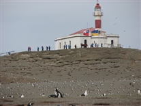
View of Island Upon Approach
Magdelena Island (Isla Magdelena in Spanish). This is in the Strait of Magellan. This is a bit out of sequence (the previous photo was taken after we arrived). However, this gives kind of an over view. It's basically a hill in the water with an old lighthouse on top (now an apparently unattended museium). No humans live on the island -- and probably no animals other than birds.
(22 Nov 2010)
Shutter Speed : 1/158.68
Date Time : 2010:11:22 04:16:13�
Equip Model : Canon PowerShot S1 IS�
Focal Length : 5.8
Aperture : F/2.8

IMG_1622.jpg
Magdelena Island, Chile
Magdelena Island (Isla Magdelena in Spanish). This is in the Strait of Magellan. This was the view looking roughly northeast along the shore immediately after arrival. All the white spots are penguins (except maybe a few spots are seagulls) -- even the ones up the hill in the distance. It's basically a small mountain of peguins.
We had a lecture before going here, when the lecturer said there were believed to be (if I remember correctly) 60,000 breeding pairs nesting here (there are also some non-breeding single penguins here). Later, in a different lecture a couple days later, the instructor said he had received additional information while in Punta Arenas. They now estimate 100,000 breeding pairs.
(22 Nov 2010)
Magdelena Island
Looking down the beach from near the dock. Never learned what the pipe was for.
I heard at least two estimates for the number of breeding pairs of penguins on this island. I seem to remember the lower number was 60,000 breeding pairs
Shutter Speed : 1/125.37
Date Time : 2010:11:22 05:10:50�
Equip Model : Canon PowerShot S1 IS�
Focal Length : 16.93
Aperture : F/4.5
A-IMG_0040.jpg
Magdelena Island, Chile
Magdelena Island (Isla Magdelena in Spanish). This is in the Strait of Magellan. This is the lighthouse (now museum). However, the real purpose of this photo is to show that it's penguins, all the way up.
(22 Nov 2010)

IMG_1621.jpg
Magdelena Island, Chile
Magdelena Island (Isla Magdelena in Spanish). This is in the Strait of Magellan. Agan, penguins, although there seem to be a few gulls in this photo (including one in flight -- if it's flying, that's a clue it isn;t a penguin.
Note the apparent absence of vegatation. I believe the only dry-land plant life I noticed while there was perhaps 6 or 8 small trees on a hilltop to the northeast. Did not get to see the other side of the island; could have been some vegatation there. Saw seaweed, but only because some penguins were carrying it uphill from the beach in their mouths.
(22 Nov 2010)
Magdelena Island
Another photo where I was trying ot show how barren this island was. Some of the black and white birds in this photo are gulls.
Shutter Speed : 1/101.13
Date Time : 2010:11:22 05:10:43�
Equip Model : Canon PowerShot S1 IS�
Focal Length : 58
Aperture : F/4.5

A-IMG_0012.jpg
Magellanic Penguins
Magdelena Island (Isla Magdelena in Spanish). This is in the Strait of Magellan. Here some of their burrow/nests are more clearly visible.
(22 Nov 2010)
Magdelena Island
Magellanic Penguins
This is looking uphill. The island is basically a mountain of penguins – and almost nothing else (there were about two sheds and a lighthouse at the high point of the island, in addition to the dock). Note essentially a total lack of vegetation. Not sure if the penguins somehow kill off the plant life, of if they chose it because of the lack of vegetation.

IMG_1629A.jpg
Magellanic Penguins
Magdelena Island (Isla Magdelena in Spanish). This is in the Strait of Magellan. I hadn't noticed before, but, looking closely at this photo, it seems the IS some vegatation on the island. There are some clumps of what might be grass. Also, the pengiins seem to have cut through some roots when they dug this burrow.
(22 Nov 2010)
Shutter Speed : 1/60.13
Date Time : 2010:11:22 05:13:05�
Equip Model : Canon PowerShot S1 IS�
Focal Length : 15.34
Aperture : F/4

IMG_1632A.jpg
Magellanic Penguin
Magdelena Island (Isla Magdelena in Spanish). This is in the Strait of Magellan.
(22 Nov 2010)
Shutter Speed : 1/60.13
Date Time : 2010:11:22 05:13:34�
Equip Model : Canon PowerShot S1 IS�
Focal Length : 58
Aperture : F/4

A-capture_90419.jpg
Magellanic Penguins
Magdelena Island (Isla Magdelena in Spanish). This is in the Strait of Magellan. Don't know what is going on, but it sure LOOKS like a fight.
(22 Nov 2010)

A-capture_90524.jpg
Magellanic Penguin
Magdelena Island (Isla Magdelena in Spanish). This is in the Strait of Magellan. Profile view.
(22 Nov 2010)
S-IMG_9223.jpg
Magellanic Penguin
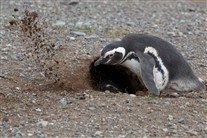
Digging a burrow.
(22 Nov 2010)
The expedition staff expected to see all the penguins brooding eggs this time of year. They were surprised to seem some chicks had already hatched. They were also surprised to seem some apparent mating activity still going on.
Hard to see what is going on here. There is a second penguin inside the burrow kicking out dirt (that’s dirt in the air on the left-had side of the photo). Not sure if this is a burrow being prepared for egg-laying or if the eggs are already in place and this is maintenance.

S-IMG_9251.jpg
Penguin With Babies
Magdelena Island (Isla Magdelena in Spanish). This is in the Strait of Magellan. I didn't actually see these, but others did. This photo is from the ship's CD -- as is the next one.
I have a memory of seeing a photo someplace on the trip where someone has gotten a photo of eggs in one of these nests. However, it apparently did not end up on the ship CD or in the Anderson's collection.
Looked on the Internet to see if baby penguins have some kind of special name (like baby geese are called goslings -- I think). Apparently not. They are just called chicks.
Have a vague memory that in the briefing/lecture on the ship from the expedition staff about penguins in general. It was said that, due to the time of year we were there, we were not going to see any eggs or chicks, Instead, we were there at the time of year for courting and mating (and we did see that acrivity).
Farther south, in Antarctica itself, most of the penguins build nexts out of pebbles. They cannot start building until the snow melts enough to expose those pebbles (and frees them from the ice so penguins can pick them up and move them). That was indeed what we saw at some places.
Because of that lecrture/briefing, it was surprising (a few days later, back on the ship) to see these photos of chicks (and eggs, if my memory of that one is correct). However, thinking about it now (as I'm writing these descriptions), that item in the lecture/briefing may have been intended to apply only to the colder areas, where long periods of continous snow cover are an issue. Not sure the weather this far north is such that this island would have a continous snow cover for much of the winter. Also, clearly, these penguins do not used pebbles to build their nests, they burrow. Finally, I suspect at the time we received that penguin lecture, the expedition staff probably did not know for sure we would be able to obtain permission to stop at this island.
Several things (such as the how the various groups of penguins may have been at different points in their reproductive cycle at different locations we visited) seemed to kind of fall into place as I have been sorting and examining these photos photos over two years after the trip. Should have done this earlier, when memories fo the trip were fresher.
While on the trip, there were so many new sights, so much new information, and so much time required for just the "business" of traveling in Antarctica, that there was little time to reflect on what we were seeing. By the "business" of traveling in Antarctica, I'm refereing to changing into heavy clothes for the landings (and then changing out of the after the landings), remembering the procedure for getting into and out of the small boats, and getting to scheduled lecture/briefings and meals on time (and, if I recall correctly, I did a pretty good job of keeping a day-by-day journal on this particular trip, using a laptop
(22 Nov 2010)
Difficult to see, but there are two chicks (their heads are in the center of the photo). Chicks do not have any white on them.

S-Lou20101122m4a_9907_Magellanic_Penguin.jpg
Penguin With Babies
Magdelena Island (Isla Magdelena in Spanish). This is in the Strait of Magellan.
(22 Nov 2010)
Difficult to see, but there are two chicks (their heads are in the center of the photo). Chicks do not have any white on them.

IMG_1676.jpg
Magellanic Penguin and Skua
Magdelena Island (Isla Magdelena in Spanish). This is in the Strait of Magellan. The one inside MIGHT be sitting on eggs. The Skua are known for preying on penguin eggs and baby penguins. However, they must eat other things too, since the eggs and babies would seem to be available for only a fraction of the year.
(22 Nov 2010)
Shutter Speed : 1/60.13
Date Time : 2010:11:22 05:49:56�
Equip Model : Canon PowerShot S1 IS�
Focal Length : 24.28
Aperture : F/3.51

IMG_1639A.jpg
John Chardine and "Friends"
Magdelena Island (Isla Magdelena in Spanish). This is in the Strait of Magellan. This is John Chardine, the ship's bird expert and wildlife photography expert, in the rust colored parka. Notice there is a penguin INSIDE his tripod in the photo and in the next one. Also, notice the ship (MS Fram) in the background. The ship is off shore, We landed on this island in the small boats.
The expedition staff wore this rust color, while blue ones were issued to the passengers. Wearing the blue parkas did not seem to be mandatory, but most people wore them. I may have gone on one of the early landings without mine, but later I realized that it probably made things easiere for the expedition staff. They could more easliy spot if a tourist was drifting off where he or she was not supposed to be.
I call them parkas, but they are really more like rain jackets. They have no thermal insulating lining. You wear them over a regular parka and/or a couple sweaters.
Also notice the people in the background are wearing life jackets (flotation jacket, required for the ride over in the small boat), while John is not wearing his. Often it was easier to just leave the life jacket on while on shore. However, you could take it off and leave it near the at the supply cache where the boats landed -- especially if you were going to do something where it would hinder you (which was probably the case with John, he had enough to carry with all his photographic equipment).
(22 Nov 2010)
Magdelena Island
Ropes had been installed (by park officials) to mark pathways on the island. The cruise line (Hurtigruten) provided blue (not thermally lined) windbreakers to all the passengers. It was not mandatory to wear them, but most people did. Also, on most (but not all) landings, many people walked around wearing their orange life vests (the vests used on the landing boats were separate from emergency life vests stored near the lifeboats).
The expedition staff generally wore orange or red jackets. John Chastin is shown here. His “expedition specialty” was birds and wildlife photography
Shutter Speed : 1/60.13
Date Time : 2010:11:22 05:17:48�
Equip Model : Canon PowerShot S1 IS�
Focal Length : 5.8
Aperture : F/4

IMG_1641.jpg
John Chardine and "Friends"
Magdelena Island (Isla Magdelena in Spanish). This is in the Strait of Magellan.
Normally, the expedtion staff went ashore before everyone else, deployed their emergency equipment, scouted out what was interesting to see, packed down paths in the snow (in some places), and put out flags to mark the limits of the areas it was OK for tourists to roam around in. Here, the park/preserve was already set up for a limited number of visitors (although the ship apparently had to get special permission for us to go ashore). These rope lines were already set up when the expedition staff came ashore.
The expedition staff briefing on landings in general asked us to not walk closer than 15 feet to a penguin. However, that rule did not apply to them. In this place, in particular, they were very curious about us.
(22 Nov 2010)
Magdelena Island
Although visitors were required to stay within the roped-off paths, the penguins were not required to stay out of them.
The ship had never previously obtained permission to actually land passengers (or expedtion staff) on this island. Apparently the expedition team had never previously encountered penguins who were this curious about humans.
Fram’s nominal capacity is 320 passengers. This trip there were 200 (exactly), with only 197 qualified for landing (by the end of the trip after some falls and injuries). There are a few places where ships with over 200 passengers are not allowed to land. The smaller-than-normal number of passengers may have been a factor that allowed this landing.
Shutter Speed : 1/60.13
Date Time : 2010:11:22 05:18:28�
Equip Model : Canon PowerShot S1 IS�
Focal Length : 14.49
Aperture : F/4

V-IMG_3609.jpg
Penguin Burrows
Magdelena Island. This was taken near the lighthouse at the top of the hill. Here this railing (to assist walking up the steep hillside) was used in place of the rope lines. This photo shows how close to the walkway the penguins built their burrows.
(22 Nov 2010)
Shutter Speed : 1/158.68
Date Time : 2010:11:22 03:53:10�
Equip Model : Canon PowerShot S3 IS�
Focal Length : 6
Aperture : F/4

IMG_1645A.jpg
Boat Landing at Magdelena Island
Magdelena Island (Isla Magdelena in Spanish). This is in the Strait of Magellan.
This shot is included to show how the small boats brought people ashore at this landing. I believe this was the only place (other than towns) where there was a dock. However, this "dock" was not something the ship could come up to, only the small boats could appraoch this dock.
There were 5 of the small boats, each (usually) carrying a maimum of 8 passengers. They divided the passengers up into six groups (with the divisions largely by the languages the passengers spoke). At the first landing, Group One went first. At the next landing, Group Two went first, and so on. There were exceptions for various reasons, but it worked out OK over the course of the trip. (If you do the math, with five boats, six groups, and eight passengers per boat, it doesn't come out to 200 passengers, but I think that allowed them to have a boat free for other uses at times during the landings.)
Once we were in Antarctica, they were supposed to be limited to having100 people on shore at any one time. This was another reason for dividing the passengers into groups for ferrying people over for the landings. Most of the people from the early groups would be back on the ship before the later groups went ashore. As best I could tell, this seemed to work itself out. If anyone from the expedition staff was counting the number of people on land, or tracking how long any speciifc individual had been on land, it was not evident to me. The limit of 100 on land seemed to be treated more as a guideline than something rigidly adhered to.
The large passenger ships that go to Antarcitca (such as the Holland American cruise ships, with room for perhaps 1800 passengers), apparenlty do no landings, they just curise past the various locations. It's clear that landing 1800 people, with no more than100 (or even "about100") allowed on land on land at any one time, would probably require them to spend two days at any one landing location (although, of course, that far south, in summer, the days were VERY long).
I have memory of hearing that after the 2011-12 season, the large ships (like 1200 or 1800 passengers) were no longer going to be permitted to even enter the Antarctic, The reason for this (as I recall) stemmed from an incident. a few years earlier than when I was there in 2010, where a small cruise ship had sun (with the passengers escaping in lifeboats and being rescued). That incident had made them realize that there were so few other ships in the region that (if large ship had sunk) the number of people in lifeboats could overwhelm the capacity for other ships to pick them up. Thus (in certain situations) people might have to spend several days in lifeboats, which, in itself, could lead to lives lost (in the lifeboats) in extemely bad weather conditions. Having relayed this story here, I was surprised to notice (a few days ago -- as this is written in early 2013) a cruise line brochure mentioning a large-ship cruise to the Antarctic Pennisula.
These were called Polar Cirkel boats, which seemed to be a brand name.
(22 Nov 2010)
Magdelena Island.
Note penguins on beach in foreground.
A small Polar Cirkel (landing craft) boat is pulling up to the island’s dock in the middle distance. This is what they called a dry landing (did not have to step into shallow water upon leaving the boat). Once in On this island, and everywhere in Antarctica, there were no docks that could handle the Fram. The Polar Cirkels (sic) were pontoon boats with outboard motors, roughly similar to Zodiacs.
The background may give some idea of how steeply the land went up from the rocky beach.
Shutter Speed : 1/125.37
Date Time : 2010:11:22 05:21:21�
Equip Model : Canon PowerShot S1 IS�
Focal Length : 58
Aperture : F/4.5

IMG_1668A.jpg
Magellanic Penguins Gathered at the Shoreline
Magdelena Island (Isla Magdelena in Spanish). This is in the Strait of Magellan.
(22 Nov 2010)
Magdelena Island
Looking down the beach roughly in the western direction. These penguins are going into the ocean to feed. Most of them probably have mates tending eggs in burrows. When they return, the other member of the pair will go out to feed. If one of them gets eaten by a seal during a feeding trip, the baby penguins also die. They generally lay two eggs, but preferentially feed the one that hatches first. The second-hatching chicks seldom live to reach maturity.
Shutter Speed : 1/60.13
Date Time : 2010:11:22 05:39:29�
Equip Model : Canon PowerShot S1 IS�
Focal Length : 44.33
Aperture : F/4

IMG_1655.jpg
Magellanic Penguins Gathered at the Shoreline
Magdelena Island (Isla Magdelena in Spanish). This is in the Strait of Magellan.
A few are entering the water in this photo. These penguins seemed to enter the water in groups of perhaps 4 to 6 (and other species we saw had a similar behavior). This seems to be a species protection thing. The concept seemed to be that if they go in groups, a single predator is going to get only one of them at most. And, there are apparently ALWAYS predators out there looking for them.
(22 Nov 2010)
Shutter Speed : 1/125.37
Date Time : 2010:11:22 05:30:34�
Equip Model : Canon PowerShot S1 IS�
Focal Length : 36.58
Aperture : F/4.5
IMG_0191.jpg
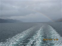
Chlean Fjords with Rainbow
Probably in Strait of Magellan after leaving Magdelena Island. Sailing toward Beagle Channel. There is a rainbow in this picture.
(Probably 22 Nov 2010)
Shutter Speed : 1/634.73
Date Time : 2010:11:21 16:02:22�
Equip Model : Canon PowerShot A495�
ISO Speed : ISO-80
Focal Length : 6.6
Aperture : F/4.5

IMG_0195A.jpg
Chilean Fjord
Probably in Strait of Magellan after leaving Magdelena Island. Sailing toward Beagle Channel.
A ship's lecturer on geology said the way he visualizes this region is to imagine he is traveling in valleys through ranges of mountains, but the valley floors are perhaps 1000 feet below the ship. There are, in effect, partially submerged mountains.
(Probably 21 Nov 2010)
Shutter Speed : 1/1002.93
Date Time : 2010:11:21 16:20:00�
Equip Model : Canon PowerShot A495�
ISO Speed : ISO-80
Focal Length : 6.6
Aperture : F/2.99

IMG_0184.jpg
Waterfalls on Creeks Flowing into Chilean Fjords
Probably in Strait of Magellan after leaving Magdelena Island. Sailing toward Beagle Channel. The streaks on the hillsides (below the treeline and the snowcap) are seasonal creeks with (many!) waterfalls that carry water from the melting snow. It was late spring here. Several waterfalls are visible in this photo. Some of these waterfalls are probably 600-800-foot sheer drops.
I believe we saw only about two human-built structures between leaving Magdelena Island and returning to the Ushuaia area on the Beagle Channel. This is a VERY sparsely populated region.
(Probably 21 Nov 2010)
Shutter Speed : 1/202.25
Date Time : 2010:11:21 15:29:27�
Equip Model : Canon PowerShot A495�
ISO Speed : ISO-80
Focal Length : 21.6
Aperture : F/5.78

IMG_0197.jpg
Waterfalls on Creeks Flowing into Chilean Fjords
Probably in Strait of Magellan after leaving Magdelena Island. Sailing toward Beagle Channel.
(Probably 21 Nov 2010)
Shutter Speed : 1/101.13
Date Time : 2010:11:21 16:20:30�
Equip Model : Canon PowerShot A495�
ISO Speed : ISO-100
Focal Length : 17.55
Aperture : F/5.03

IMG_0207A.jpg
Chilean Fjords
After leaving Magdelena Island. Sailing toward Beagle Channel. This might be from the Cockburn Chennel or the Ballenero Channel.
(Probably 22 Nov 2010)
Shutter Speed : 1/125.37
Date Time : 2010:11:21 18:11:18�
Equip Model : Canon PowerShot A495�
ISO Speed : ISO-80
Focal Length : 9.84
Aperture : F/3.51
IMG_0281A.jpg
Beagle Channel Chart/Map
Photo of a map attached to wall in an area of the Fram called the Bistro (Deck 4). This chart shows a series of glaciers flowing into the west end of the Beagle Channel.
Shutter Speed : 1/30.06
Date Time : 2010:11:23 05:53:49�
Equip Model : Canon PowerShot A495�
ISO Speed : ISO-400
Focal Length : 6.6
Aperture : F/2.99
S-IMG_9357.jpg
Glacier, Beagle Channel
Beagle Channel, Chile. I'm not sure which galcier this is.
(23 Nov 2010)
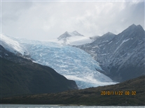
IMG_0252.jpg
Glacier, Beagle Channel
Beagle Channel, Chile. I'm not sure which galcier this is.
(23 Nov 2010)
Shutter Speed : 1/1509.65
Date Time : 2010:11:22 08:32:52�
Equip Model : Canon PowerShot A495�
ISO Speed : ISO-125
Focal Length : 17.55
Aperture : F/5.03
IMG_0258A.jpg
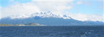
Mountains in Sunlight
Beagle Channel, Chile. Mountains in sunshine! Finally! If I remember correctly, the white stuff above the mountains is not clouds, but rather is show blowing off the mountaintops.
(23 Nov 2010)
Shutter Speed : 1/1243.34
Date Time : 2010:11:22 11:10:30�
Equip Model : Canon PowerShot A495�
ISO Speed : ISO-160
Focal Length : 9.84
Aperture : F/3.51
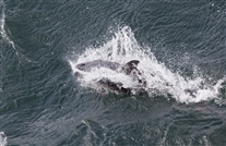
S-IMG_9398.jpg
Dolphin
I'm pretty sure it was in the Beagle Channel where we saw this, but I'm not certain. This is a dolphin or porpoise.
(Probably 23 Nov 2010)

A-capture_92727.jpg
Whale Tail
I'm pretty sure it was in the Beagle Channel where we saw this, but I'm not certain. This is the tail of a humpback whale.
(Probably 23 Nov 2010)
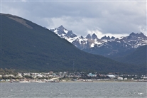
IMG_0265A.jpg
Ushuaia from the Beagle Channel
We sailed past Ushuaia traveling east. Ushuaia is on the north shore of the Beagle Channel. We did not stop. From this distance (and in the good daylight), you can see two or three ski slopes cut into the forests at elevations above the town (all to the left of the center of the photo). The airport is just above water level at about the leftmost 1/4 of this photo.
(23 Nov 2010)
Shutter Speed : 1/809
Date Time : 2010:11:22 11:46:01�
Equip Model : Canon PowerShot A495�
ISO Speed : ISO-125
Focal Length : 21.6
Aperture : F/5.78
S-IMG_9415.jpg
Puerto Williams from the Beagle Channel
Puerto Williams, Chile. This town is on the south shore of the Beagle Channel, east of Ushuaia. It is on Navarino Island (which makes up much of the south shore of the Beagle Channel. The population is said to be 2000, but the town seemed larger to me. There are several military installatiions there. Could be that 2000 is the population other than military and their dependents.
Ushuaia also has at least one large miliitary base (navy). I suspect a major purpose of the military installations in each town is to watch the military installations in the other one.
(23 Nov 2010)

IMG_1735.jpg
MS Fram
Puerto Williams, Chile. This was the last place the ship itself could dock until we returned to Ushuaia at the end of the cruise.
(23 Nov 2010)
Shutter Speed : 1/404.5
Date Time : 2010:11:23 17:26:05�
Equip Model : Canon PowerShot S1 IS�
Focal Length : 6.89
Aperture : F/4.5

IMG_1738.jpg
Signpost in Puerto Williams
Puerto Williams, Chile.
(23 Nov 2010)
Shutter Speed : 1/101.13
Date Time : 2010:11:23 17:28:32�
Equip Model : Canon PowerShot S1 IS�
Focal Length : 8.88
Aperture : F/4.5

IMG_1729A.jpg
Whale Skeleton Outside Local Museum
Puerto Williams, Chile. There was stuff about Charles Darwin, etc. in this Museum. Much of South America seems to LOVE Darwin and the Theory of Evolution.
(23 Nov 2010)
Shutter Speed : 1/404.5
Date Time : 2010:11:23 15:41:24�
Equip Model : Canon PowerShot S1 IS�
Focal Length : 5.8
Aperture : F/4.5

IMG_0274A.jpg
Scenery South of Peurto Williams
Puerto Williams, Chile. The expedition staff led several excursions here, but not commercial extra-cost stuff. I went on a hike to a (small) waterfall south of town. This was on the way back (I'd gotten ahead of most of the group). This is looking back the way I'd come (from the waterfall). A local had passed me with four dogs walking with him (not on leashes). The guy in blue is another passenger.
The waterfall (which was OK, but not great) was from a mill pond.
(23 Nov 2010)
Shutter Speed : 1/158.68
Date Time : 2010:11:22 16:55:10�
Equip Model : Canon PowerShot A495�
ISO Speed : ISO-160
Focal Length : 21.6
Aperture : F/5.78

IMG_0280A.jpg
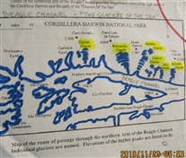
Map (Cape Horn)
Another photograph of a chart taped to the Fram's Bistro wall. The circled area includes Cape Horn (Cabo de Hornes), which, as stated earlier is not where I had thought it was. The (Chilean) national park called Cabo de Hornes includes more islands than the island of Cabo de Hornes itself.
This map shows a portion of the convoluted boundary between Chile and Argentina in this area. The boundary is a north-south line coming from the north until it strikes the Beagle Channel, the the channel itself becomes the bourdary. The national park in Argentina from which I took an earlier photograph showing mountains in Chile, is on the dashed line in the area just below the "A" in the work "Argentina" (written vertically).
I may have said in the discussion of a previous photo that Cape Horn is an island (and perhaps it is -- that wasn't clear during the trip). It could be that Horn (or Horne) is the name of the island, and the cape is a geographical feature on the south side of it.
Shutter Speed : 1/25.28
Date Time : 2010:11:23 05:53:40�
Equip Model : Canon PowerShot A495�
ISO Speed : ISO-400
Focal Length : 6.6
Aperture : F/2.99

IMG_1742.jpg
Cape Horn
Taken from the Drake Passage (or, perhaps, from near the Drake Passage, which might not start until you get past Cape Horn). Cape Horn is the dark land mass on the left hand side. That's a rainbow on the left.
They had tentatively planned a landing on Cape Horn, but it was cancelled due to rough seas. I suspect they bat well below 0.500 with respect to really being able to land at Cape Horn.
(24 Nov 2010)
Shutter Speed : 1/1002.93
Date Time : 2010:11:24 06:52:17�
Equip Model : Canon PowerShot S1 IS�
Focal Length : 16.93
Aperture : F/5.03

IMG_0289.jpg
Cape Horn
Taken from (or from near) the Drake Passage. Apparently the word "Horn" has nothing to do with the shape of the island or (possibly) with musical instruments. I believe I heard it was named for a Dutch sea captain named Hoorne (or maybe van Hoorne).
(24 Nov 2010)
Shutter Speed : 1/250.73
Date Time : 2010:11:23 06:29:49�
Equip Model : Canon PowerShot A495�
ISO Speed : ISO-80
Focal Length : 21.6
Aperture : F/5.78

S-IMG_9578.jpg
Cape Horn
Taken from (or from near) the Drake Passage. Anke Timmerberg, the ship's photographer took this one. It's better than any of mine. The weather was very bad this day. I don't believe anyone complained about not goiing out in this to see Cape Horn.
(24 Nov 2010)

S-IMG_9573.jpg
Wind and Waves in Drake Passage.
A fine November gale in the Drake Passage (between South America and the Antarctic Pennisula).
(Probably 24 Nov 2010)

S-IMG_9660.jpg
Wave in Drake Passage
A fine November gale in the Drake Passage. The bow (or prow) of the ship is dropping down into the trough between two waves here. This is not a wave coming toward the ship about the wash over the bow.
(Probably 24 Nov 2010)

A-Sea-Sick-Bags.jpg
Ship Interior -- Drake Passage
A fine November gale in the Drake Passage (well, perhaps not SO fine for everyone). The word here is apparently the Norwegian word for something like "in case of sea sickness".
(Probably 24 Nov 2010)

A-capture_100044.jpg
Cormorant (Probably an Antarctic Shag)
Possibly in Drake Passage.
I'm somewhat uncertain where many of these birds-in-flight photos were taken, but I have put all of them in with the Drake Passage photos.
There was a "lecture" that was a workshop (out on deck) about techniques for taking photos of flying birds. I believe the workshop was taught by John and Lou, and possibly by Anke too. I did not attend (which I regret greatly). My best memory is that the workshop was held while we were in the Strait of Magellan, after we left Magdelena Island (which makes sense, it would have had a pretty low turnout in much of the weather -- and sea conditions -- we experienced in the Drake Passage).
The idea (which I learned later) is that several kinds of birds tend to fly alongside (WITH) the ship in several areas where we were crusing. This enables you to have time to set up, aim, and focus your camera (I realize that nowadays cameras largely focus themselves, but, I think you know what I mean). The bird is (sort of) alongside you rather than flying past you (as could be the case if the photographer were stationary).
Another factor that enables this is that many modern (expensive -- or fairly expensive) cameras have an continous autofocus feature. That is, once the camera focuses on, say, a flying bird, it holds that focus, automatically adjusting, if necessary, as long as the shutter release button is held down. Thus, in theory, the bird stays in focus even if it drifts farther away or comes closer, while the shutter button is held down. This assumes you are taking continous photos with camera (I think these cameras take perhaps 4 or 5 photos per second).
Using this technique, you take a LOT of pictures. Then, afterward, you look thru them to find the best ones. Then you erase the others off your camera card.
I had never heard of this tracking autofocus feature. Got out the manuan of my Canon SX-1. It had a feature to take a continous string of photos (either 1.6 per second or one every 1.6 seconds, I forget which). However, on the SX-1, what ever the camera was focused on for the first photo in a burst, it held the same focus for the others. It did not adjust when the targer moved.
What is shown here are photos taken by others on the cruise.
A few of these photos MAY have been taken before we got to the Drake Passage. However, I suspect that most or all of them were in the passage (especially the second day, when the weather improved somewhat).
(Perhaps 25 Nov 2010)
There was a workshop on bird photography on deck on this day (which I did not attend). Because of that, I’ve put several of these bird-in-flight photos here, even though some or all of them may have been taken on different days.
This is comorant. This likely was taken on a different day, since I don’t remember actually seeing any of cormorants until we reached Antarctica.
I suspect this is a frame “clipped” from a video sequence (not sure if they had a camcorder or if it is the video or “movie” mod

A-capture_100001.jpg
Cormorant (Probably an Antarctic Shag)
Possibly in Drake Passage. I'm somewhat uncertain where many of these birds-in-flight photos were taken, but I have put all of them in with the Drake Passage photos.
(Perhaps 25 Nov 2010)

S-IMG_9913.jpg
Black-browed Albatross
Possibly in Drake Passage. I'm somewhat uncertain where many of these birds-in-flight photos were taken, but I have put all of them in with the Drake Passage photos.
(Perhaps 25 Nov 2010)


S-IMG_9720.jpg
Wandering Albatross
Possibly in Drake Passage. I'm somewhat uncertain where many of these birds-in-flight photos were taken, but I have put all of them in with the Drake Passage photos.
(Perhaps 25 Nov 2010)

S-IMG_9831.jpg
Cape Petrel (probably)
Possibly in Drake Passage. I'm somewhat uncertain where many of these birds-in-flight photos were taken, but I have put all of them in with the Drake Passage photos.
(Perhaps 25 Nov 2010)

S-IMG_9706.jpg
Possibly a Southern Giant Petrel
Possibly in Drake Passage. I'm somewhat uncertain where many of these birds-in-flight photos were taken, but I have put all of them in with the Drake Passage photos.
(Perhaps 25 Nov 2010)
I’d never heard of this tracking auto focus thing. Looked at the manual for my ~2004 SLR-like Canon S1 IS camera. It has the multiple shot option (but 1.6 frames per second, not 10). On my camera, the camera does the autofocus and exposure settings for the first frame in the series, but then those same settings are used for all the other photos in the series.

S-IMG_9889.jpg
Possibly a Southern Giant Petrel
Possibly in Drake Passage. I'm somewhat uncertain where many of these birds-in-flight photos were taken, but I have put all of them in with the Drake Passage photos.
(Perhaps 25 Nov 2010)
The “professional” wildlife photographers have top-of-the-line single lens reflex (SLR) digital cameras that have an option called something like tracking auto focus. They camera not only focuses on the bird, but it adjusts the focus and exposure settings as the bird drifts closer or father from the ship. They also use an option where they shot 10 frames per second for a few seconds. Then they pick out the best photos from the set. The results can be amazing – like this one.

A-capture_101911.jpg
Possibly a Southern Giant Petrel
Possibly in Drake Passage. I'm somewhat uncertain where many of these birds-in-flight photos were taken, but I have put all of them in with the Drake Passage photos.
(Perhaps 25 Nov 2010)

S-IMG_9949.jpg
Possibly a Gray-headed Albatross
Possibly in Drake Passage. I'm somewhat uncertain where many of these birds-in-flight photos were taken, but I have put all of them in with the Drake Passage photos.
(Perhaps 25 Nov 2010)

IMG_1756A.jpg
Possibly a Light-mantled Sooty Albatross
Possibly in Drake Passage. I'm somewhat uncertain where many of these birds-in-flight photos were taken, but I have put all of them in with the Drake Passage photos.
I tried to take some birds-in-flight photos with my cameras. This one (and the photos that follow) are mine. As you can see, they are not nearly as good as the ones taken by people with better training (and who actually attended the workshop).
(24 Nov 2010)
Shutter Speed : 1/1243.34
Date Time : 2010:11:24 12:27:28�
Equip Model : Canon PowerShot S1 IS�
Focal Length : 58
Aperture : F/6.3

IMG_0293A.jpg
Probably a Cape Petrel
More of the ones I took (the ones that are of lower quality)
(24 Nov 2010)
Shutter Speed : 1/501.46
Date Time : 2010:11:24 15:19:44�
Equip Model : Canon PowerShot A495�
ISO Speed : ISO-80
Focal Length : 21.6
Aperture : F/5.78

IMG_0299A.jpg
Probably a Cape Petrel
More of the ones I took (the ones that are of lower quality)
(24 Nov 2010)
Shutter Speed : 1/501.46
Date Time : 2010:11:24 15:20:18�
Equip Model : Canon PowerShot A495�
ISO Speed : ISO-80
Focal Length : 21.6
Aperture : F/5.78

IMG_0304A.jpg
Unidentified
More of the ones I took (the ones that are of lower quality)
(24 Nov 2010)
Shutter Speed : 1/1243.34
Date Time : 2010:11:24 15:26:44�
Equip Model : Canon PowerShot A495�
ISO Speed : ISO-80
Focal Length : 12.05
Aperture : F/4

A-Antarctica_Southern_Ocean001.jpg
Antarctic Map (Overview)
Shows overview of continent. Drake Passage is between South America and Antarctic Pennisula, near upper left-hand corner of this map.

A-06-Cruise-02-001.jpg
South Shetland Islands and Antarctic Pennisula (Map)
We left Drake Passage by sailing through the Nelson Strait, the widest passage between any two of the South Shetland Islands (I think they may have called this the King George Strait on the ship, the strait seems to have had several names over the years). We were bound for Deception Island.
These charts were prepared by the great Bob Anderson. The red dots represent places south of the South Shetland Island where we actually did landings.

A-07-Cruise-03-001.jpg
Deception Island (Map)
The island is a flooded caldera left behind by the collapse of a large volcano. The flooded interior is called Port Foster and the entrance (a break in the circular wall) is called Neptune's Bellows. If anyone has ever been "inside" Diamond Head near Honolulu, this is similar (but MUCH large, and flooded, and the entrance is natural, not something tunneled or cut with machines).
We stopped two places inside (spending pretty much the entire day), Whalers Bay and Telefon Bay. There had been a planned hike over "wall" to a Chinstrap Penguin rookery at a place called Baily Head. The hiking route is marked by the blue path going east and northeast from Whalers Bay (the path went up the inside wall of the volcanic caldera, then down the outside wall, and then back again on the return trip).
Sadly, I never got to Baily Head. I was assigned to the third group of hikers. However, my group's hike was cancelled due to bad weather just after we got onshore (and the landings of all of the non-hikers were cancelled for this location. There was essentially a blizzard going on when my group of hikers got on shore (the returns to the ship were also stopped, just as we got onshore). Fortunately, the extreme blowing snow did not last very long (and they resumed taking people back to the ship. However, perhaps 1/2 of the passengers never got on shore at Whalers Bay.
The first group of hikers actually madei it to Bailey Head, The second group could not get over the summit due to blizzard (whiteout) conditons. The expedition people in the second group had radios to contact the ship and the expedition people in the third group of hikers, which is why I never got to Baily Head.
Too bad, in a way. Baily Head was our only chance to see a colony of Chinstrap Penguins (although we ran across two or three lone Chinstraps at other places (there may have been two of them at one location, mixed in with other types of penguins).
Notice on the map that the east side of Deception Island is essentially straight. This is a natural feature more evident from the map than when you see it from the boat from a distance). I never got a good explanation for what was going on, but the expedition staff was pretty sure it had to be related to a geological fault of some kind (as I was too),
Also, not that the indicated course for the ship indicates the ship stuck to the far north side of Neptune's Bellows both going in and coming out. That is accurate. There is a submerged rock in the center of the gap. Apparently the safe channel for ships the size of the Fram is along that north side.

A-capture_94127.jpg
Porposing Penguins
I'm not sure where this was taken. I've put it here because near the entrance to Neptune's Bellows was one of the places where I saw penguins doing this.
Several of them swim in a line. Each one traces out a series of S-shaped curves (in the vertical plane) as they seem to go in and out of the water. It's similar to a porpoise and a bit like a human swimmer doing the butterfly stroke.
This is not a multiple exposure showing some kind of time sequence for a single penguin. They swin in a line (or sometimes two parallel lines), sort of playing follow the leader as is indicated here.
(24 Nov 2010)

IMG_0321.jpg
Approaching Nepture's Bellows
Deception Island. South Shetlands. Off Antarctic Pennisula.
l
This photo and the next one were taken from the observation lounge on Deck 7.
(26 Nov 2010)
Shutter Speed : 1/317.37
Date Time : 2010:11:25 04:25:03�
Equip Model : Canon PowerShot A495�
ISO Speed : ISO-80
Focal Length : 6.6
Aperture : F/2.99

IMG_0325.jpg
Approaching Nepture's Bellows
Deception Island. South Shetlands. Off Antarctic Pennisula.
The ship had to stay way over to the right (east) going in. There is a submerged rock in the center of the "entrance" (what SEEMS to be the entrance) and they said the other side had "foul water" (wasn't sure what that meant in this context). The also have to hug that same side on the way out.
(26 Nov 2010)
They said a Hurtigruten ship hit the rock in the center of the channel some years earlier. At first I thought that was the cause of the ship sinking I'd known about. However, it appears (for the ship that struck this rock) passengers were transferred to another ship, and the damaged ship was repaired in place. It apparently ruined the cruise for the passegers in the ship that struck the rock and the ship that picked up the passengers (the second -- now very overcroweded -- ship took everybody back to Ushuaiaas quickly as they could).
Clearly this was something the Hurtigruten people did not talk about much. I suspect the fact that is was mentioned (without anyone asking, that I was aware of) may have been a slipup on someone's part. I don't think the ship's crew or the expedition staff would cover up this incident -- they seemed quite open about several things. However, it's also something they don't highlight in their advertising, understandably.
Shutter Speed : 1/158.68
Date Time : 2010:11:25 04:33:51�
Equip Model : Canon PowerShot A495�
ISO Speed : ISO-80
Focal Length : 6.6
Aperture : F/2.99

A-IMG_0037.jpg
Whalers Bay
Deception Island. South Shetlands. Off Antarctic Pennisula.
The building and tanks on shore were originally a whale processing facility (perhaps from around 1900-1920). Later, in World War II, it became a (very small) British military base (this may have been called their Base B). The British had about 20 bases (named for letters, A to Z, but apparently they did not use some of the intermediate letters, since they had less than 26 bases).
It is all in ruins now. There were some graves here too, with (if I recall correctly) three visible markers (but the I seem to recall hearing the number of graves is more like 10 or 12 -- some may have been unmarked or else the markers have vanished with time, storms, and volcanic activity).
(26 Nov 2010)
Apparently, many of the metal tanks were intially used in the whale processing, but were later used for avaition fuel and heating oil for the British base.
Apparently, the British somehow had the idea the Nazis might invade Artarctica, so their bases were basically lookout stations. I suspect the only country anyone would imagine would possilby would want to invade Antarctica would be Nazi Germany (and the British are the only nation that would seriously expect them to do it).
The volcano still has occasional activity. Some of the damage to the buildings and storage tanks on the island was said to caused by volcanic activity (which would include seismic activity before and during eruptions).
Volcanis activity apparently also included mudslides. As I envisioned the process, heated rocks for volcanic activity (such as steam vents and hot springs) could melt or soften show up at higher elevations. This could, in turn, lead to formation of a pool of mud up there, which could become unstable and flow down the steep inner caldera wall. The mud flow coulld be triggered by seismic activity related to the volcanic activity, but that was probably not a necessary step in the process.

L-DSCF0274.jpg
Whalers Bay
I believe this photo shows all of the large structures at this old station except for the airplane hanger, which is off to the left hand side of this photo (north). There were several items on shore that are too small to show up at this distance. One was a boat (shown in later photo). Another was a vehicle that looked like a road grader or snowplow, wihich may have been used for the airstrip.
This was the largest set of ruins that we saw. I suspect pretty much all of the abandoned structures and equipment are still there (but some may have been covered with ice and snow -- and here, mudslides). The oldest structures are probalby only a bit more than 100 years old. Also, the climate probably creates a refrigerator effect, which slows the rate at which wood decays. We were told to not enter any of the buildings.
Knowing how things work, I imagine bases, structures, etc. are removed nowadays when they are abandoned, due to environmental regulations under the Antarctic Treaty (before they get old enough to be classed as historic, as there are, I believe). However, we saw at least one uninhabited closed-up structure (on Petermann Island) that was called an emergency refuge. I wonder if that's a way of delaying having to remove the structure.
(26 Nov 2010)
Shutter Speed : 1/648.07
Date Time : 2010:11:26 04:48:58�
Equip Model : FinePix F80EXR�
ISO Speed : ISO-200
Focal Length : 8.7
Aperture : F/4.76

A-IMG_0041.jpg
Whalers Bay
I believe this was the main building from the era when it was a British Base. Some of the damage shown here probably came from mudslides rolling down the steep slope behind the building (and possibly from snow avalanches too).
(26 Nov 2010)
Shutter Speed : 1/1618
Date Time : 2010:11:26 09:09:45�
Equip Model : Canon PowerShot S3 IS�
Focal Length : 72
Aperture : F/4.5

A-capture_12202010.jpg
Whalers Bay
This is the first group of hikers ferried to Whalers Bay starting out.
(26 Nov 2010)

IMG_0338A.jpg
Whalers Bay
Deception Island. South Shetlands. Off Antarctic Pennisula.
Taken after I got on shore (and after the whiteout conditions had died down a bit). Notice the beach is black "sand". At Telefon Bay (a landing later in the day, still in the Deception Island caldrea), the black "sand" was really tiny pebbles, perhaps slighty smaller than a BB. I'm not sure it was the same here -- Teleforn Bay may have been glacial deposit, and this beach may have been formed by a different process.
The building in the distanceis an old airplane hanger from the World War II era. The (unpaved) runway was apparently on the (now) snow-covered flatish area on the left hand side of the hanger.
Those are Gentoo penguins in the foreground (one standing, three laying on the ground).
(26 Nov 2010)
Shutter Speed : 1/501.46
Date Time : 2010:11:25 07:38:37�
Equip Model : Canon PowerShot A495�
ISO Speed : ISO-100
Focal Length : 21.6
Aperture : F/5.78

IMG_0339A.jpg
Whalers Bay
Deception Island. South Shetlands. Off Antarctic Pennisula.
This is the Fram, photographed from Whalers Bay. The mountains in the background are on the opposite side of the caldera. The "dock" where passengers load on and off the small boat is visible in its "down" position on the side of the ship. One of the small boats is visible on the right hand edge of the photo.
(26 Nov 2010)
Shutter Speed : 1/501.46
Date Time : 2010:11:25 07:38:44�
Equip Model : Canon PowerShot A495�
ISO Speed : ISO-100
Focal Length : 21.6
Aperture : F/5.78

IMG_0394A.jpg
Whalers Bay
Deception Island. South Shetlands. Off Antarctic Pennisula.
There were several pieces of ruined equipment on the beach (and, notice the black "sand").
(26 Nov 2010)
Shutter Speed : 1/2005.85
Date Time : 2010:11:25 08:57:00�
Equip Model : Canon PowerShot A495�
ISO Speed : ISO-80
Focal Length : 6.6
Aperture : F/4.5

IMG_0407.jpg
Whalers Bay
Deception Island. South Shetlands. Off Antarctic Pennisula.
Looking southward along the beach.
(26 Nov 2010)
Shutter Speed : 1/1002.93
Date Time : 2010:11:25 09:12:20�
Equip Model : Canon PowerShot A495�
ISO Speed : ISO-80
Focal Length : 21.6
Aperture : F/5.78

IMG_0411A.jpg
Whalers Bay
Deception Island. South Shetlands. Off Antarctic Pennisula.
The blonde in the foreground is a Russian girl passenger (probalbly around age 16 -- she seemed to be traveling with here grandmother). Russian was not one of the languages in which the expedition team gave lectures. She attended the lectures givein in English (and she may have spoken French too).
(26 Nov 2010)
She had been in hiking Group 2, the group that got stopped by blizzard conditions at the summit. Note how much ice has collected on her hat. She was not wearing a blue parka -- as I indicated wearing them was optional, but most people did wear them.
Shutter Speed : 1/809
Date Time : 2010:11:25 09:13:23�
Equip Model : Canon PowerShot A495�
ISO Speed : ISO-160
Focal Length : 21.6
Aperture : F/5.78

IMG_0418A.jpg
Linda Wright at Telefon Bay
Deception Island. South Shetlands. Off Antarctic Pennisula.
Note the pengiun and one of the small boats on the left hand side of this photo.
(26 Nov 2010)
Shutter Speed : 1/809
Date Time : 2010:11:25 13:33:46�
Equip Model : Canon PowerShot A495�
ISO Speed : ISO-160
Focal Length : 6.6
Aperture : F/4.5

IMG_0425A.jpg
Telefon Bay
Deception Island. South Shetlands. Off Antarctic Pennisula.
Same day as the blizzard earlier. It had cleared up somewhat by afternoon when we moved to the other landing on Deception Island. There is sunshine off in the distance.
My memory is that a glacier flowing down from inner wall had formed sort of a cove (Telfon Bay). I had climbed up and was standing on top of the glacier. The surface of the glacier is black because of repeated ashfalls from volcanic activity (although, clearly, the eruptions in recent decades have been much smaller than the ones that created the island (and later partially destroyed it).
The gap in the mountains in the distance is Neptune's Bellows, where we entered the flooded caldera.
The actual bay was behind (and below) the point where I was standing to take this photo.
(26 Nov 2010)
Shutter Speed : 1/1243.34
Date Time : 2010:11:25 13:50:59�
Equip Model : Canon PowerShot A495�
ISO Speed : ISO-80
Focal Length : 12.05
Aperture : F/4

IMG_0431A.jpg
Skua
Deception Island. South Shetlands. Off Antarctic Pennisula.
As indicated in a photo from a few days earlier, these birds have the reputation for living off penguin eggs and penguin eggs. However, they must have other food sources too, since penguin eggs and young penguins are available at only certains times of the year.
(26 Nov 2010)
Shutter Speed : 1/125.37
Date Time : 2010:11:25 14:06:10�
Equip Model : Canon PowerShot A495�
ISO Speed : ISO-100
Focal Length : 21.6
Aperture : F/5.78

S-DSC_2329.jpg
Swimming in the Antarctic Ocean
Deception Island. South Shetlands. Off Antarctic Pennisula.
Well, it's "swimming" (getting most of my body wet) in Telefon Bay. That's me on the left hand side.
In theory, you could swim at any landing. However, the only place I'm aware that anyone did it was at Telefon Bay. They had told us the water temperature was 31.8 degrees F, but I later received a certificate, which listed the water temperature as 32.1. Apparently because of the dissolved salt content, ocean water can get quite a bit below 32 F without freezing.
I had read beforehand (and also after the trip) that "warm spots" (or "warm springs") can sometimes form at certan places inside the Deception Island caldera (called Port Foster), due to extremely mild volcanic activity. Often cruise lines will try to do their landings near those spots, and do "the swim" thing at those locations (I'm guessing the "warm water" at places like that might be somewhere in the 40s F). There did not seem to be any volcanic heating at this location.
The boat in the background is related to the semi-organized swimming activity. They would hold off swimmers from entering the water until there was a boat available and a boatload of prospective swimmers (7, 8, or 9 of us) ready to start undressing. Then we would get in, get out (quickly), quickly throw on some clothing, and immediately get onto that waiting boat for an exclusive, swimmers-only, express trip back to the ship.
The guys in red or orange here are ship's crew. The way there are dressed gives some idea of how cold it was here (the air temperature). However, their dress exaggerates things a bit. They are out longer than any particular group of tourists. Also, they spend their time in the moving boats out on the water, where it probably feels colder than on land (where you are sometimes sheltered from the wind).
Apparently, the name "Antarctic Ocean" is falling out of favor. They now often call it The Southern Ocean.
(26 Nov 2010)

S-DSC_2337.jpg
Leaving the Antarctic Ocean
Deception Island. South Shetlands. Off Antarctic Pennisula. Telefon Bay.
Sad to say, but the fat bald guy is me.
I remember thinking as I left the water that I wanted to be smiling, so people would think I was enjoying this. Doesn;t look to me like a very convincing smile.
(26 Nov 2010)

S-IMG_0221.jpg
Young Seal
Deception Island. South Shetlands. Off Antarctic Pennisula. Telefon Bay.
There were two very young seals laying on the beach at Telefon Bay. The expedition team had put up flags or other markers indicating we were not to get within perhaps 20 feet of them. They did not seem to mind that we were there.
We saw seals on shore at one other landing (that I can recall). Except for penguins, those were the only "land animals" that I recall seeing in Antarctica (and both seals and penguins are largely "sea animals". There were several kind of flying birds on land (penguins do not fly). Also saw seals swimming and on floating chunks of ice.
(26 Nov 2010)

S-IMG_0257.jpg
Young Seal
Deception Island. South Shetlands. Off Antarctic Pennisula. Telefon Bay.
There were two very young seals laying on the beach at Telefon Bay. The expedition team had put up flags or other markers indicating we were not to get within perhaps 20 feet of them. They did not seem to mind that we were there.
I believe this is a leopard seal.
(26 Nov 2010)
I learned something about photographing animals (by comparing my photos of these seals with better ones that others had taken): always try to get the animal's eyes (and try to get them open).

S-IMG_0225.jpg
Young Seal
Deception Island. South Shetlands. Off Antarctic Pennisula. Telefon Bay.
There were two very young seals laying on the beach at Telefon Bay. The expedition team had put up flags or other markers indicating we were not to get within perhaps 20 feet of them. They did not seem to mind that we were there.
I believe this is a crabeater seal. If it is indeed a crabeater seal (and the other one was indeed a leopard seal), that may be odd because leopard seals eat crabeater seals (and these were only about 10-15 feet apart). However, I suspect the "eating" is done while both are in the water. Also, I suspect the eating is done by seals larger than the leoapard seal here, and the eaten ones are smaller than crabeater seal here.
(26 Nov 2010)
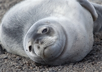
S-IMG_0226.jpg
Young Seal
Deception Island. South Shetlands. Off Antarctic Pennisula. Telefon Bay.
There were two very young seals laying on the beach at Telefon Bay. The expedition team had put up flags or other markers indicating we were not to get within perhaps 20 feet of them. They did not seem to mind that we were there.
I believe this is a crabeater seal. The name is not accurate. They apparently eat mostly krill, not crabs.
(26 Nov 2010)

S-IMG_0262.jpg
Telefon Bay
Deception Island. South Shetlands. Off Antarctic Pennisula.
This photo was taken by someone (Anke, probably) looking west from near where we entered the water to swim. Notice someone is up on the glacier at the upper right portion of the photo. The next photo was probably taken by someone up there, although the photographer was probably standing at a location more like the upper left hand corner of this photo.
The black ridge beyond the water is the glacier. The white snow is probably relatively fresh snow that fell after the most recent dusting of volcanic ash.
(26 Nov 2010)

S-IMG_0289.jpg
Telefon Bay
Deception Island. South Shetlands. Off Antarctic Pennisula.
Telefon Bay. This is taken standing on the glacier, which curves around on the left hand side of this photo. The small boat is entering the bay. The Fram is probably hidden behind the arm of the glacier at right center of this photo. The swimming was done from the little spit of black "sand" (glacial deposit) just to the right of where the small boat is. If you look closely, there seems to be some people standing there, and possibly also some of the equipment the expedition team brought ashore for the landing. The young seals were in that area too.
(26 Nov 2010)

A-08-Cruise-04-001.jpg
Route to Cuverville Island Off Antarctic Pennisula (Chart)
Shows route across Bransfield Strait, then through the Gerlache Strait to Cuverville Island.
There is blowing snow up on top of the mountains and ice floating in the water.

IMG_0439.jpg
Morning in Artarctica
I believe this is a view of the Antarctic mainland. However, it could be Brabant Island
(27 Nov 2010)
Shutter Speed : 1/1002.93
Date Time : 2010:11:26 04:06:27�
Equip Model : Canon PowerShot A495�
ISO Speed : ISO-80
Focal Length : 21.6
Aperture : F/5.78

IMG_0442.jpg
Morning in Artarctica
I believe this is a view of the Antarctic mainland. However, it could be Brabant Island.
(27 Nov 2010)
Shutter Speed : 1/809
Date Time : 2010:11:26 05:26:15�
Equip Model : Canon PowerShot A495�
ISO Speed : ISO-80
Focal Length : 21.6
Aperture : F/5.78

V-IMG_4152.jpg
Waiting to go Ashore
I believe we were waiting to be called for our turn for the landing at Cuverville Island.
Did not realize it at the time, but, looking at these pictures (including several I didn't put in this album), it looks like went on the trip expecting they would have a dorky hat contest somewhere along the way -- and I wanted to win.
About a year prior to this, I'd seen some baseball World Series games played on some very cold nights (in Boston, I believe). I'd noticed some players had baseball caps with built-in ear flaps. That SEEMED at the time, like a pretty good idea. I found a Detroit Tiger cap of that kind on the internet and ordered one for this trip. I'm wearing it here. In these photos, it looks pretty dorky.
(Possibly 27 Nov 2010)
Shutter Speed : 1/60.13
Date Time : 2010:11:29 15:04:29�
Equip Model : Canon PowerShot S3 IS�
Focal Length : 6
Aperture : F/4

IMG_0463.jpg
Approaching Cuverville Island Through Floating Ice
Cuverville Island.
This was taken from inside a Polar Cirkel boat as we approached the landing point. The metal rods are handholds to use entering and leaving the boat (almost always both done from the front of the boat).
There are parallel lines of penguins and people (the "blue penguins") on shore on the left hand side of this photo.
I was in one of the last groups of people to go to this landing. There is a line of people from earlier groups lined up to go back to the ship. Some of them are getting onto the boat nest to the shore.
There was a lot of floating ice adjacent to shore, which got worse while my group was on shore. I suspect they would not have done this landing if they had known how ice conditions would change while the landing was going on.
(27 Nov 2010)
Shutter Speed : 1/1002.93
Date Time : 2010:11:26 09:47:16�
Equip Model : Canon PowerShot A495�
ISO Speed : ISO-80
Focal Length : 6.6
Aperture : F/4.5

IMG_0465.jpg
Cuverville Island Viewed During Approach
Cuverville Island.
Taken while still offshore. The flag above and to the right of the center of this photo was put out by the expedition staff to mark where people were allowed to go so as, to not interfere with the penguin pathways (but they had no rules about staying away from us).
The people and the penguins on the shore are moving in roughly parallel paths.
(27 Nov 2010)
Shutter Speed : 1/809
Date Time : 2010:11:26 09:47:30�
Equip Model : Canon PowerShot A495�
ISO Speed : ISO-80
Focal Length : 21.6
Aperture : F/5.78

A-capture_94929.jpg
Floating Ice Off Landing Area
Cuverville Island.
Taken while ashore. Looking out at a boat of passengers returning to the ship. The boats with no "bluejackets" in them are acting like icebreakers to try to keep a path open thru the ice field.
(27 Nov 2010)

IMG_0497.jpg
Floating Ice Off Landing Area
Cuverville Island.
Another view of how the ice collected near shore. This was taken after I had hiked (in deep snow) to a high spot, perhaps 100 feet above sea level.
(27 Nov 2010)
Shutter Speed : 1/1243.34
Date Time : 2010:11:26 10:25:27�
Equip Model : Canon PowerShot A495�
ISO Speed : ISO-80
Focal Length : 14.8
Aperture : F/4.5

IMG_0473.jpg
The Penguin Trail
Cuverville Island.
Gentoo penguins walking along the shore. Notice floating ice offshore behind them. Also notice they have made two parallel tracks.
(27 Nov 2010)
Shutter Speed : 1/1243.34
Date Time : 2010:11:26 09:55:12�
Equip Model : Canon PowerShot A495�
ISO Speed : ISO-80
Focal Length : 21.6
Aperture : F/5.78

IMG_0474.jpg
Gentoo Pengin Rookery
Cuverville Island.
This is a large Gentoo penguin rookery.
The dark stuff is basically penguin poop. The cold air gives kind of a refrigerator effect, so it doesn't smell too bad (but you ARE aware of it, and what it is). However, they take precautions to prevent it from being tracked onto the ship. There, where conditions are warmer, it gets really ripe. Some got onto the corridor on Deck 5, and it was bad (fortunately, it was not close to my cabin).
This rookery was to the left of the landing site. My memory is that there was another one to the right of the landing site. Also, there may have been a second one to the right, off at more of a distance.
The next two photos are of this same general area, but use different zoom settings and are cropped differently in order to give some idea of how large this rookery is. Look closely at the area slightly above and to the right of the center of the photo, where there is a pyramid-shaped ice structure, then move to the nest photo.
(27 Nov 2010)
Shutter Speed : 1/1509.65
Date Time : 2010:11:26 09:58:17�
Equip Model : Canon PowerShot A495�
ISO Speed : ISO-80
Focal Length : 6.6
Aperture : F/4.5

IMG_0474A.jpg
Gentoo Pengin Rookery
Cuverville Island.
Detail of the penguin rookery.
(27 Nov 2010)
Shutter Speed : 1/1509.65
Date Time : 2010:11:26 09:58:17�
Equip Model : Canon PowerShot A495�
ISO Speed : ISO-80
Focal Length : 6.6
Aperture : F/4.5
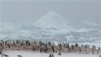
IMG_0474B.jpg
Gentoo Pengin Rookery
Cuverville Island.
Even more detailed view of the penguin rookery.
I don't recall what the pyramid-shaped thing was -- an iceberg or snow on a rock on the other side of the ice-choked water. My guess is that it's on land -- that our landing area was on the shore of a small bay, and this is a snow collected on a rock on the opposite side of the bay. It was probably more than a half-mile ride from the ship to the landing point. The ship was not in sight while we were on land. This may have been the only time we were on land out of sight of the ship (there was a time when we were in the boats out of sight of the ship; that comes later).
(27 Nov 2010)
Shutter Speed : 1/1509.65
Date Time : 2010:11:26 09:58:17�
Equip Model : Canon PowerShot A495�
ISO Speed : ISO-80
Focal Length : 6.6
Aperture : F/4.5

IMG_0479A.jpg
Gentoo Penguins "Sledding"
Cuverville Island.
The two penguins in the foreground are doing a sled-type motion. They lay on their stomachs and slide (or swim) along the ground, propelled by their legs.
(27 Nov 2010)
Shutter Speed : 1/1002.93
Date Time : 2010:11:26 10:01:43�
Equip Model : Canon PowerShot A495�
ISO Speed : ISO-80
Focal Length : 21.6
Aperture : F/5.78
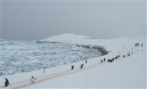
IMG_0513A.jpg
Gentoo Penguin Two-lane Highway
Cuverville Island.
Line of penguins moving (between rookeries? or maybe to and from an area where it's easier for them to enter and exit the water?). Notice they have two lanes in the snow.
(27 Nov 2010)
Shutter Speed : 1/1509.65
Date Time : 2010:11:26 10:42:27�
Equip Model : Canon PowerShot A495�
ISO Speed : ISO-80
Focal Length : 6.6
Aperture : F/4.5

A-capture_94401.jpg
Gentoo Penguins
Cuverville Island.
They are so cool.
We saw more Gentoo Penguins in Antarctica than any other kind (I say "Antarctica," since -- countng that island in the Starit of Magellan, inc Chile, we probably really saw more Magellanic Penguins than any other type). Surprisingly, the guidebooks claim there are fewer Gentoo Penguins there than the other two type we saw (Chinstrap and Adelie) -- and LOTS fewer (100,000s of thousands of Gentoos, versus millions of the other two).
(Probably 27 Nov 2010)

L-DSCF0316.jpg
Carl (not smiling)
I believe this was taken on Couverville Island.
(Probably 27 Nov 2010)
Shutter Speed : 1/372.22
Date Time : 2010:11:27 19:15:26�
Equip Model : FinePix F80EXR�
ISO Speed : ISO-200
Focal Length : 7
Aperture : F/4.29

A-capture_95118.jpg
Seal
Probably Cuverville Island.
Leopard seal, I think. THIS is the reason why they go into the water in groups of 4 to 6.
Notice how the the nostrils on this one are more "open" than in the earlier photo of the young ones sleeping on the beach. I suspect they have kind of a valve at that point (which closes when they dive). This one may have just surfaced and is taking in a breath.
(Probaby 27 Nov 2010)

IMG_0522.jpg
Blue Ice
Cuverville Island.
This is from the boat on the way back to the ship. A lot of the floating ice had blue coloring to it, sometime there were layers of blue -- and a nice shade of blue too.
(27 Nov 2010)
Shutter Speed : 1/1002.93
Date Time : 2010:11:26 11:07:25�
Equip Model : Canon PowerShot A495�
ISO Speed : ISO-80
Focal Length : 6.6
Aperture : F/4.5

A-09-Cruise-05-001.jpg
Cuverville Island, Paradise Harbor, and Neko Harbor (Map)
OK, this is complicated. The plan was to go from Cuverville Island (a morning landing) to Paradise Harbor in the afternoon. However, when we got to the entrance to Paradise Harbor, the captain could see it was full of floating ice. He decided to backtrack and go to Neko Harbor. Both Paradse Harbor and Neko Harbor are on the Antarctic mainland. So Neko Harbor was out actual first time to set foot on the Antarctic continent.
(Antarctica LOOKS like a contient. However, I've read that may be somewhat of an illusion because most of it is covered with a thick ice cap. At least some geographers believe that IF it were possible to remove the icecap, it might look more like a group of islands, some of them quite large, but not continent-sized.)
I was a bit disappointed we "missed" Paradise Harbor. My understanding is that there was a small dock there (suitable for the small boats to use). There are supposed to be buildings from an abandoned Argintine base there (or at least one that has been closed for several years). The story is that an Argentine physician stationed there sort of berserked out, setting one of the buildings on fire (and he may have killed or injured one of his co-workers, I'm a bit fuzzy on the details of the story). Apparently, you walk past the building of the old base to get to the penguin rookery at the landing.
Because of "turning back" to get to Neko Harbor, the landing at Neko Harbor was pretty late (long after dinner). Looks like I have a photo taken after 9:30 pm (and my recollection is that we were one of the earlier groups off the ship at this landing). They could do this late landing because of the large number of daylight hours at this latitude this time of year. We were slightly more than two degrees north of the Antarctic Circle and only about four weeks before the longest day of the year (in that hemisphere). The sun went down every night, but it never REALLY got pitch dark.
I beleive Nekko Island was the place the expedition staff stayed on shore for several hours, after the passgers left, to test some tents (and latrine-type equipment). They were hoping to get approval for using this stuff in furture years to be able to sell extra-cost excursions for tourists to spend a night sleeping on the Antarctic Continent. I think that's one reason they were anxious to make at least one landing on the mainland (which most of the passengers wanted too). Turned out we were able make a second landing on the mainland a couple days later.

IMG_0530A.jpg
Linda at Neko Harbor
This is one where I tried to level the horizon. Note how the date on the photo is not horizontal.
(27 Nov 2010)
Shutter Speed : 1/202.25
Date Time : 2010:11:26 19:15:25�
Equip Model : Canon PowerShot A495�
ISO Speed : ISO-80
Focal Length : 6.6
Aperture : F/2.99

S-IMG_1037.jpg
Penguin Rookery
Neko Harbor.
The very tall man is Francis (Frank) Wiese, one of the expedition staff. He is Swiss, but has lived in Alaska for several years. He was fluent in English, German, and French (and maybe other languages too).
You can see from the straps on the backs of the blue jackets that these people kept their life jackets on at this location. It was pretty compact, so there was no great distance to walk -- and no hills to climb.
(27 Nov 2010)


IMG_0541A.jpg
Snowy Sheathbill
Probably at Neko Harbor. On this one you can see a hint of the unusal shape of the bill that is the source of their name.
(Probably 27 Nov 2010)
Shutter Speed : 1/125.37
Date Time : 2010:11:26 19:27:19�
Equip Model : Canon PowerShot A495�
ISO Speed : ISO-80
Focal Length : 21.6
Aperture : F/5.78
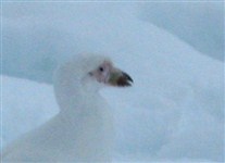
IMG_0541B.jpg
Snowy Sheathbill
Probably at Neko Harbor. This is cropped from the previous photo, and implicitly enlarged to the point where It's gettig fuzzy. The orangish portion of the bill closest to its head is the sheath.
(Probably 27 Nov 2010)
Shutter Speed : 1/125.37
Date Time : 2010:11:26 19:27:19�
Equip Model : Canon PowerShot A495�
ISO Speed : ISO-80
Focal Length : 21.6
Aperture : F/5.78

S-IMG_1077.jpg
Chinstrap Penguin
Probably Neko Harbor. There was ONE lone Chinstrap at Neko Harbor. It seemed to be wandering around looking for others of it's kind.
There was a small amount of beach here that was not snow-covered.
(Probably 27 Nov 2010)

A-10-Cruise-06-001.jpg
To Petermann Island and Back (Chart)
There are actually two route traces shown here, almost on top of each other. We went south, through the Lemaire Channel, to Petermann Islans, and then retrraced the path.
On the way back through the Lemaire Channel, several of us were put down down in the small boats and had a water-level-eye view of the trip. It was a narrow channel with high walls of rock and ice on both sides, with an occasonal small penguin colony here and there. There were medium-size of chunks of floating ice drifting down the channel, a few of them with seals sleeping on them.
On a clear day, they would have been an unforgetable experience for the beauty and strangeness of the place. On this day, it was foggy, snowy, and cold -- unforgetable, but not in a totally good way.
The small penguin colonies are mentioned above. There was one thing about them that was evident here (and in a few other places) that I did not capture in a photo (and I;m not sure it is possible to capture). Saw some of them at an elevations perhaps 100 to 200 feet above the water, in steep areas that were almost like cliff faces. It seemed amazing that such awkward, clumsy-looking creatures could walk (or climb) up the steep paths that SEEMED to be the only way they could reach these locations. Could be there were alternative (less steep) ways to get to where they were, but, if so, it was not obvious.

IMG_1769A.jpg
Gentoo Penguin -- MS Fram in Background
Petermann Island.
Notice the snow-covered cliffs behind the Fram.
Petermann Island is about 1 degree latitude north of the Anrarctic CIrcle. This was as far south as we went. I believe cruises later in the season later (in the Southern Hemisphere summer) reach the Antarctic Circle, There is less floating ice at that time. However, I'm not sure if there are any actual landing points south of the Antarctic Circle.
(28 Nov 2010)
Shutter Speed : 1/1002.93
Date Time : 2010:11:28 09:50:37�
Equip Model : Canon PowerShot S1 IS�
Focal Length : 23.22
Aperture : F/5.03

IMG_1788.jpg
Birds Together
Petermann Island. This isn't a great photo, but it's the best one I have that shows something of the variety of birds on this rock outcrop next on the shoreline, This point had cormorants, Gentoo Penguins, Adelie Penguins, and (if I remember correctly) two Chinstrip Penguins, all within a region perhaps 25 feet across. The next five photos (following this one) were also taken in this area.
Most of the birds on the left, nearest the snow, are Gentoo Penguins (with the white spots on their heads), There are three cormorant nests in this photo (all built on little pedistals) -- a male (I think) is feeding a female sitting on the center nest. The cormorants have more elongated necks than penguins -- and they can fly.
The penguins closest to the center of the photo, and those on the right are Adelie Penguins (no white spot on their heads). I did not get the Chinstraps in this photo.
My understanding is that the proper name for these cormorants is Antarctic Shag.
I'm almost certain this spot was the only place we saw these three types of Antarctic pegnuins so close together (and the only place I remember where we say Antarctic Shags nesting).
A photo I should have taken (but did think of it) was that perhaps 20-25 people were standing beside me as I took this photo. We were a lot more interested in these birds than they were in us.
I was not 100% centain of the directions north, south, east, and west while I was actually on this island (the ship approached the island from the north, but may have had to maneuver a bit to get close to the landing point. However, my best guess is that this cluster of birds was at the farthest south point I was at while walking on the island. Thus, this photo (along with the five that follow it) was taken at the farthest south I have ever been -- and almist certainly ever will be. This was roughly one degree north of the Antarctic Circle.
(28 Nov 2010)
Shutter Speed : 1/1002.93
Date Time : 2010:11:28 10:03:15�
Equip Model : Canon PowerShot S1 IS�
Focal Length : 15.95
Aperture : F/4.5

IMG_1779A.jpg
Cormorant Nest with Adelie Penguins in Foreground
Petermann Island. The specific type of cormorant is Antacrtic Shag.
And I AM aware of possible derivations for the name Antarctic Shag -- the Brits DID have several bases in this region.
(28 Nov 2010)
Shutter Speed : 1/634.73
Date Time : 2010:11:28 10:00:13�
Equip Model : Canon PowerShot S1 IS�
Focal Length : 58
Aperture : F/4.5


S-IMG_1247.jpg
Chinstrap Penguin
Petermann Island.
I'm pretty sure this is from Petermann Island. These are among the very few chinstraps that I saw (not being able to visit the colony at Baily Head on Deception Island due to bad weather). If this is indeed from Petermann Island, my memory is there were only two of them there (in the area that had a mixture of birds). If there indeed were only two, the third penguin in the back is a different type (proabaly an Adele).
(28 Nov 2010)

S-IMG_1456.jpg
Chinstrap Penguin
Petermann Island.
Again, I'm pretty sure this was as Petermann Island.
(28 Nov 2010)
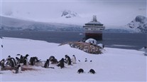
IMG_1790A.jpg
Penguin Rookery Petermann Island
Petermann Island.
(28 Nov 2010)
Shutter Speed : 1/1618
Date Time : 2010:11:28 10:07:40�
Equip Model : Canon PowerShot S1 IS�
Focal Length : 16.93
Aperture : F/6.3

IMG_1792A.jpg
Penguin Rookery Petermann Island
Petermann Island.
There were several penguin rookeries on this island. Also, this building (closed up). I think it is owned by Argentina, and used only occasionally.
The thing to the right of the building (in this view) is a memorial cross for three members of a British survey team who died near here in 1982. I have a vague memory there were also some ruins here from an early expedition (early 1900s), but I did not spot that in any of my photos.
The variety of birds, the dramatic view (especially from up on the hill), and (finally) the sunshire were the main things here.
(28 Nov 2010)
Shutter Speed : 1/1618
Date Time : 2010:11:28 10:07:54�
Equip Model : Canon PowerShot S1 IS�
Focal Length : 19.95
Aperture : F/6.3
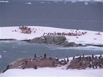
IMG_1793.jpg
Penguin Rookery Petermann Island
Petermann Island.
(28 Nov 2010)
Shutter Speed : 1/1002.93
Date Time : 2010:11:28 10:08:03�
Equip Model : Canon PowerShot S1 IS�
Focal Length : 58
Aperture : F/5.6
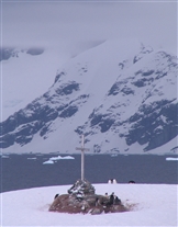
IMG_1802A.jpg
Memorial to British Survey Team Members
Petermann Island.
(28 Nov 2010)
Shutter Speed : 1/1002.93
Date Time : 2010:11:28 10:15:10�
Equip Model : Canon PowerShot S1 IS�
Focal Length : 58
Aperture : F/6.3
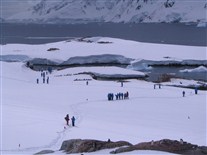
IMG_1806.jpg
Blue Penguins (in the distance)
Petermann Island.
Looking down from the top of the hill.
The trail in the snow going off to the left hand side of this photo goes to the rocky outcrop where the cormorant nests and the mixed group of peguins shown in an earlier photo. I believe the trail going out of sight in to the right hand side of the photo goes to the place where the small boats landed. Doesn't seem that I took photos that include either of those locations while I was up on top of this hill.
Some of the small flags the expedition staff generally put out in advance of the first tourist boat landings to mark walking trails are visible in this photo. They wanted people to stay on these paths for our safety and to minimize disturbance to the natural environment. For example, the paths were selected to (generally) keep at least 20-30 feet away from any bird nesting areas (with one or two exceptions, where the landings were along rocky shorelines and penguins had built nests near the only places the small boats could access). I'm pretty sure they were following procedures spelled out in part by their permiits from the Antarctic Treaty organization and in part by their insurance carrier.
As previously mentioned, there were no regarding how closely penguins could approach tourists, so long as we stayed on our trails. We would try to stop in the trail to maintain the minimum15-foot distance if a penguin seemed to be about to cross the trail in front of us, but sometimes they were interested in one of us, not what was on the other side of the trail.
(28 Nov 2010)
Shutter Speed : 1/2005.85
Date Time : 2010:11:28 10:23:49�
Equip Model : Canon PowerShot S1 IS�
Focal Length : 14.49
Aperture : F/6.3

IMG_1807.jpg
Fram With Dramatic Backdrop
Petermann Island.
Note penguins in foreground.
(28 Nov 2010)
Shutter Speed : 1/1618
Date Time : 2010:11:28 10:23:57�
Equip Model : Canon PowerShot S1 IS�
Focal Length : 8.6
Aperture : F/6.3

IMG_1805.jpg
Valerie
Petermann Island.
Too bad she wasn't smiling. Bob Anderson's photo (probably) from Neko Harbor is better.
(28 Nov 2010)
Shutter Speed : 1/1243.34
Date Time : 2010:11:28 10:20:30�
Equip Model : Canon PowerShot S1 IS�
Focal Length : 14.49
Aperture : F/6.3
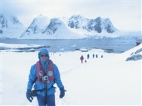
V-IMG_4533.jpg
Carl on Petermann Island
Petermann Island.
Carl near the hilltop at Petermann Island -- finally smiling, and in sunlight.
The sunlight did not last long. Probably the first thing the expedition staff said at the first briefing/lecture about Antarctice was something like: expect sudden and extreme changes in weather. That was accurate.
(28 Nov 2010)
Shutter Speed : 1/3236.01
Date Time : 2010:11:28 08:12:12�
Equip Model : Canon PowerShot S3 IS�
Focal Length : 6
Aperture : F/8

IMG_1850A.jpg
Penguins and Fram
Petermann Island.
(28 Nov 2010)
Shutter Speed : 1/1243.34
Date Time : 2010:11:28 10:46:13�
Equip Model : Canon PowerShot S1 IS�
Focal Length : 24.28
Aperture : F/6.3

IMG_1832A.jpg
Penguins and Fram
Petermann Island.
At this place I was enchanted by the views of penguins with the Fram in the background. Kept trying to take the perfect photo of that. Then, once I got home, couldn't decide which of those photos WAS the perfect one.
(28 Nov 2010)
Shutter Speed : 1/1618
Date Time : 2010:11:28 10:39:20�
Equip Model : Canon PowerShot S1 IS�
Focal Length : 15.34
Aperture : F/6.3

IMG_1844.jpg
Penguins and Fram
Petermann Island.
(28 Nov 2010)
Shutter Speed : 1/1002.93
Date Time : 2010:11:28 10:43:04�
Equip Model : Canon PowerShot S1 IS�
Focal Length : 28.54
Aperture : F/5.6


S-IMG_1182.jpg
Penguins at Petermann Island
Petermann Island.
The one at the far left is making a "calling?"sound. Saw/heard them doing this at several locations. I MAY, someplace, have a brief segment of video that captures this sound. However, I need to finish with these stills (and other stills) before I worry about examining/sorting video.
(28 Nov 2010)

IMG_1855A.jpg
Penguin Nests
Petermann Island.
This was near the area where the small boats landed. Here you can see a close-up of one of their nest areas. These Gentoo penguns make nests of small pebbles. They seemed to be in the nest-building, courting, and mating part of the cycle while we were there.
They were stealing pebbles from each other's nests at this time. Wasn't sure if that behavior is limited to only the nest-building phase or if they continue to do that even afrter the babies come.
I'm pretty sure this is mostly mud, but some of it might be penguin poop.
(28 Nov 2010)
Shutter Speed : 1/634.73
Date Time : 2010:11:28 10:49:44�
Equip Model : Canon PowerShot S1 IS�
Focal Length : 18.74
Aperture : F/4.5

A-BootRoom-2.jpg
Ship Boot Room
As indicated in the description of the most recent "map," after leaving Petermann Island, several of us had the opportunity to traverse part of the Lemaire Channel in the small boats (an extra-cost excursion).
I suspect this photo and the next one were not really taken on that day, but this seemed like a good place to put them. They are related to loading and unloading the small boats at the ship.
The ship supplied boots to use during landing. The boots were stored in this room on Deck 2, near where we entered the boats (the boats were pulled inside the ship and stored in same this general area between landings). The boots are on racks, sorted by shoe size.
They said the reason for this was to control what microbes, seeds, insects, etc. was transported onto and off of Antarctica and its offshore islands, in accordance with the Antarctic Treaty and the shipping company's permits. There was a shallow trough containing some kind of disinfectant and detergent that we waded through between this boot room and the boats (we did the disinfectant process both entering the small boats and leaving them). There was an absorbant (and mildly abrasive) doormat-type material at the bottom of the troughs.
It was possible to bring one's own boots -- and perhaps 6 or 8 people did that. However, they wanted "personal boots" to also be stored in this room during the trip (they had a separate rack for those boots). As discussed elsewhere in this album, I'm pretty sure a reason for keeping these boots off the higher (carpeted) decks was to avoid having penguin poop tracked to other parts of the ship.
With regard to minimizing contaminating the Antarctic (in accordance the treaty and the ship permits), before the first landing after crossing the Drake Passage, we went throught an exercise where we took our personal coats and pants to an area to have them vacuumed by members of the crew (including vacuuming the insides of pockets). The "blue penguin" jackets were exempt from this, since they had issued them to us the first day on the ship, so those jackets could not have picked up much "contaminnation" (there are probably flaws in that logic, but I wasn't going to argue). What they wanted to clean was stuff we would be wearing on shore that could have picked up seeds, microbes, etc. from other continents. When I say coats here, it means coats we might wear instead of or under the "blue penguin" unlined jackets.
There were charts at various places on the ship giving the layout of the various decks. The place where this boot room (and the place next to it where the small Polar Cirkel boats were stored between landings) was called the "Car Deck". Apparently, the ship was designed with the intention that someday this will be used as a ferry along the coast of Norway (this will probably when they build a new ship that takes over the Antarctic cruises). Apparently Hurtigruten (the company that owns the Fram) had 6 or 8 ships operating as coastal ferrys. They also do Arctic cruises of various kinds in the Northern Hermisph

A-IMG_0078.jpg
Ship-Boat Transfer
Again, this might have been a different day, but this seemed a good place to put this photo.
This is a photo of people getting off the boat. My memory is that we most often used the front entrance to the boat (where the handrails are) even from this little fold-down dock on the side of the ship. However, this particular time, they went from the side of the boat

V-IMG_4624.jpg
Ship-Boat Transfer
This one I'm pretty sure is loading for the Lemaie Channel "cruise". Here they are loading from the front of the small boat.
Shutter Speed : 1/250.73
Date Time : 2010:11:29 01:30:59�
Equip Model : Canon PowerShot S3 IS�
Focal Length : 8.8
Aperture : F/4

V-IMG_4625.jpg
Lemaire Channel "Cruise" in Small Boats
Valerie did not go on this. She took several photos from the ship.
(28 Nov 2010)
Shutter Speed : 1/404.5
Date Time : 2010:11:28 09:50:50�
Equip Model : Canon PowerShot S3 IS�
Focal Length : 29.3
Aperture : F/4

V-IMG_4638.jpg
Lemaire Channel "Cruise" in Small Boats
Carl at upper right with the white hat under his blue hood.
(28 Nov 2010)
Shutter Speed : 1/404.5
Date Time : 2010:11:28 09:52:49�
Equip Model : Canon PowerShot S3 IS�
Focal Length : 48.6
Aperture : F/4

IMG_1863.jpg
Lemaire Channel "Cruise" in Small Boats
(28 Nov 2010)
Shutter Speed : 1/1002.93
Date Time : 2010:11:28 12:19:05�
Equip Model : Canon PowerShot S1 IS�
Focal Length : 5.8
Aperture : F/4.5

V-IMG_4662.jpg
Lemaire Channel "Cruise" in Small Boats
(Probably 28 Nov 2010)
Shutter Speed : 1/1618
Date Time : 2010:11:28 09:58:35�
Equip Model : Canon PowerShot S3 IS�
Focal Length : 6
Aperture : F/4

V-IMG_4732.jpg
Lemaire Channel "Cruise" in Small Boats
Taken from the ship. That tiny dot in the upper left region of this photo is some of the small boats -- maybe all of them. At this point we could just barely see the ship (if at all). That channel that looked so narrow on the map was stating to look pretty big. And our boat was starting to seem pretty small, compared to the surroundings.
(28 Nov 2010)
Shutter Speed : 1/1618
Date Time : 2010:11:28 11:53:37�
Equip Model : Canon PowerShot S3 IS�
Focal Length : 17.7
Aperture : F/4

V-IMG_4735.jpg
Lemaire Channel "Cruise" in Small Boats
Again, the tiny dot is some or all of the small boats.
(28 Nov 2010)
Shutter Speed : 1/1618
Date Time : 2010:11:28 11:55:25�
Equip Model : Canon PowerShot S3 IS�
Focal Length : 6
Aperture : F/5.03
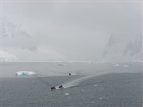
V-IMG_4739.jpg
Lemaire Channel "Cruise" in Small Boats
Coming back toward the ship (which slowed down to let us catch up: Thanks Captain). Two of the five small boats broke down on this excursion and had to be towed. Only one of the boats under tow shows up in this photo.
I was expecting the next landing (later that same day) to be "interesting" with two of the small boats our of service, but they were repaired within just a few hours.
(28 Nov 2010)
Shutter Speed : 1/1618
Date Time : 2010:11:28 11:57:00�
Equip Model : Canon PowerShot S3 IS�
Focal Length : 14.5
Aperture : F/4

V-IMG_4756.jpg
Lemaire Channel "Cruise" in Small Boats
(28 Nov 2010)
Shutter Speed : 1/1618
Date Time : 2010:11:28 12:01:31�
Equip Model : Canon PowerShot S3 IS�
Focal Length : 14.2
Aperture : F/4.5
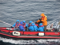
V-IMG_4761.jpg
Lemaire Channel "Cruise" in Small Boats
That's me in the dark glasses facing the camera at the front of the boat. There is a blanket wrapped across my lower legs. The ship provided these for everyone on this excurson, but mine kept slipping off as I turned one way and then another to see things (the synthetic bib-type ski pants I was wearing had kind of a slippery surface, which didn't help in keeping the blanket in place).
(28 Nov 2010)
Shutter Speed : 1/634.73
Date Time : 2010:11:28 12:02:39�
Equip Model : Canon PowerShot S3 IS�
Focal Length : 61.4
Aperture : F/4

S-IMG_1541.jpg
Lemaire Channel "Cruise" in Small Boats
Floating iceberg. My best memory is that this was roughly the size of a house. And, of course, that was just the ~10% that was above the surface.
(Probably 28 Nov 2010)

S-IMG_7479.jpg
Four Seals
From Lemaine Channel small boat "cruise". These were on a floating slab of ice.
I believe these are crabeater seals.
(28 Nov 2010)

S-IMG_7412.jpg
Frightened Seal
This seal was sleeping on a small flat-topped iceberg. About three of the small boats came up on this seal at the same time, sort of surrounding it. When it woke up and saw us, it was very frightened. We backed off a bit, but I'm pretty sure everyone in the boats felt badly about this.
I believe this is a crabeater seal.
(28 Nov 2010)

S-IMG_7414.jpg
Frightened Seal
From Lemaine Channel small boat "cruise". The fightened seal.
I believe this is a crabeater seal.
(28 Nov 2010)

IMG_1902A.jpg
Lemaire Channel "Cruise" in Small Boats
This was taken from one of the small boats once the weather had "cleared" enough to be able to see the cliffs on both side of the channel reasonably clearly. For much of the two hours or se we were in the small boats, these cliffs were only dimly visible through the fog and snow. They were pretty dramatic to seen in person, but the fog does not photograph well.
That's blowing snow at the top. This cliff is perhaps 400 or 500 feet high. The entire channel was lined with things like this.
(28 Nov 2010)
Shutter Speed : 1/1243.34
Date Time : 2010:11:28 14:30:55�
Equip Model : Canon PowerShot S1 IS�
Focal Length : 16.93
Aperture : F/6.3

A-11-Cruise-07-001.jpg
Port Lockroy (Map)
The right hand track line (path) shows the route we took a day earlier, when we tried to go to Paradise Harbor, then backtracked to Neko Harbor.
The (roughly parallel) left hand track show our route to Port Lockroy. Port Lockroy seems to initially been a small bay on the west side of Weincke Island. There is a tiny island inside that bay. The tiny island is named Goudier Island. Goudier Island was the site of British Base A during World War II.
The military base was later converted to a scientific base, and then was abandoned around 1962. In the mid-1990s, the base was refurbished and is now operated during Southern Hemisphere summers as a museum and (perhaps more important) a souvineer shop. The name Port Lockroy now seems to be loosely applied to Goudier Island and the buildings on the island.
Several rooms in what had been the main building of the base have been restored to roughtly what they might have looked like shortly before the time scienfitric base closed in 1962. There were some sleds (sleges) outside. I'm not sure if they were representative of 1962, or it they represented an earlier era.

IMG_0557.jpg
MS Fram Stern
Back onboard the Fram, after leaving Port Lockroy. It was snowing pretty good.
(28 Nov 2010)
Shutter Speed : 1/1002.93
Date Time : 2010:11:27 07:24:22�
Equip Model : Canon PowerShot A495�
ISO Speed : ISO-80
Focal Length : 6.6
Aperture : F/2.99

IMG_0560.jpg
Outside the Bar on Deck 7
There had been snow accumulation probably between one and two inches. The bar staff had made this tiny tabletop snowman outside on Deck 7.
(Probably 28 Nov 2010)
Shutter Speed : 1/125.37
Date Time : 2010:11:27 07:42:35�
Equip Model : Canon PowerShot A495�
ISO Speed : ISO-200
Focal Length : 21.6
Aperture : F/5.78

IMG_0561A.jpg
Snow Accumulation on Cabin Balcony and Railing
Before the trip, I had sort of scoffed at the possibility of reserving a cabin with a balcony for a trip to the Antarctic. However, it turned out to be very convenient to step out there briefly and take a photo of something interesting that we might pass by. Some of the photos of large icebergs taken the next day were taken from that balcony.
(Probably 28 Nov 2010)
Shutter Speed : 1/250.73
Date Time : 2010:11:27 08:25:33�
Equip Model : Canon PowerShot A495�
ISO Speed : ISO-80
Focal Length : 6.6
Aperture : F/2.99

IMG_0619.jpg
Port Lockroy Sign
Near the landing point on Goudier Island.
(28 Nov 2010)
Shutter Speed : 1/250.73
Date Time : 2010:11:27 17:27:52�
Equip Model : Canon PowerShot A495�
ISO Speed : ISO-80
Focal Length : 12.05
Aperture : F/4

S-IMG_7543.jpg
Port Lockroy
Goudier Island from the ship. The snow cliffs in the background are the shore of Weincke Island, which forms the bay that is Port Lockroy. There was a Chilean gunboat anchored in the bay (perhaps 80 feet long), but I apparently never got a photo of it.
(28 Nov 2010)

IMG_0582.jpg
Port Lockroy
The building is the former main building of the British base. It's now museum, post office, souriver shop, etc.
At this place, the rule about not approaching closer to 15 feet from a penguin was changed to don't approach closer than 5 feet. There were a LOT of penguins on a VERY small island. They have penguins apparently living under the building. The sledges in the foreground are museum artifiacts. They are no longer used (in fact, dogs have been banned from Antarctica for a few decades now under the Antarctic Treaty.
Note the Union Jack flying on the island.
(28 Nov 2010)
Shutter Speed : 1/1002.93
Date Time : 2010:11:27 17:02:53�
Equip Model : Canon PowerShot A495�
ISO Speed : ISO-80
Focal Length : 6.6
Aperture : F/2.99

S-IMG_1680.jpg
Port Lockroy
"Blue Penguins" are going toward the entrance ot the main building of the old base.
(28 Nov 2010)

A-Store-Port-Lockroy_2_.jpg
Port Lockroy
This is in the post office and gift shop room. There were perhaps 4 other rooms set up as a museum.
(28 Nov 2010)

A-capture_100355.jpg
Port Lockroy
Souvineer shop at the bottom of the world. This seemed to be sort of a crossroads. There was a bulliten board with letters (in unstamped envelopes) attached to it. Letters seemed to be people at one Antarctic base writing to residents of another base. Had the impression they all pass through here at one time or anohter.
You could also buy British Antarctica stamps and mail postcards from here. I think the mail went by ship to the UK (with pickup from this post office perhaps once every 2-3 weeks or so) and then entered regular internaton mail from the UK.
(28 Nov 2010)

IMG_0597.jpg
Port Lockroy
This is one of the young women who work at this station talking about one of the museum rooms in the building.
The museum, gift shop, and post office are open only during the Southern Hemisphere summmer. It is staffed (this year) by four young women, three British and one German (which seemed and interesting combination, given the reason these British bases were built in the early 1940s -- apparently a relatively large fraction of tourists visiting the Antarctic are German). This is one of the women telling us about the painting on the wall, which was apparently discovered while they were refurbishing the building in the 1990s (to open it as a museum). The painting (directly on the wall) probably dates from the 1950s.
The four women live in a different (much smaller) building (similar to a quonset hut) on the island. Their accomodations are apparently quite limited. One of the first of our small boats to land carried their dirty laundry to the ship, where it was washed and dried by someone in the ship's crew. One of the last of our small boats carring people to the island returned it to them.
(28 Nov 2010)
Shutter Speed : 1/12.91
Date Time : 2010:11:27 17:15:03�
Equip Model : Canon PowerShot A495�
ISO Speed : ISO-800
Focal Length : 6.6
Aperture : F/2.99
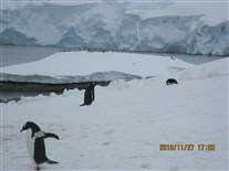
IMG_0587.jpg
Port Lockroy
I believe these penguins are on the eastern edge of Guider Island. The next version is a cropped version of this photo, trying to illsutrate how many penguins are in the prior photo
(28 Nov 2010)
Shutter Speed : 1/404.5
Date Time : 2010:11:27 17:03:56�
Equip Model : Canon PowerShot A495�
ISO Speed : ISO-80
Focal Length : 21.6
Aperture : F/5.78

IMG_0587A.jpg
Port Lockroy
Cropped version of prevous photo.
(28 Nov 2010)
Shutter Speed : 1/404.5
Date Time : 2010:11:27 17:03:56�
Equip Model : Canon PowerShot A495�
ISO Speed : ISO-80
Focal Length : 21.6
Aperture : F/5.78

IMG_0602.jpg
Penguins on Weincke Island
Next photo is a cropped version of this one. The next photo is of the portion of this photo just below and to the left of the center of this photo.
(28 Nov 2010)
Shutter Speed : 1/317.37
Date Time : 2010:11:27 17:21:12�
Equip Model : Canon PowerShot A495�
ISO Speed : ISO-80
Focal Length : 21.6
Aperture : F/5.78

IMG_0602A.jpg
Penguins on Weincke Island
As best could tell, Port Lockroy is an anchorage in a bay in Weincke Island. Goudier Island is in that bay.
(28 Nov 2010)
Shutter Speed : 1/317.37
Date Time : 2010:11:27 17:21:12�
Equip Model : Canon PowerShot A495�
ISO Speed : ISO-80
Focal Length : 21.6
Aperture : F/5.78

IMG_0610A.jpg
Snowy Sheathbill
Port Lockroy. Unfortunately, I did not get a good angle to enable seeing the structure of the bill, which gives this species it's common name.
(28 Nov 2010)
Shutter Speed : 1/317.37
Date Time : 2010:11:27 17:23:54�
Equip Model : Canon PowerShot A495�
ISO Speed : ISO-80
Focal Length : 21.6
Aperture : F/5.78

IMG_0617A.jpg
Penguin Carrying Rock to Build Nest
Port Lockroy. This penguin may have stolen this from one of its neighbors. They did that in the nest-building stage. I don't know if they continue to do it after eggs are layed.
(28 Nov 2010)
Shutter Speed : 1/404.5
Date Time : 2010:11:27 17:27:21�
Equip Model : Canon PowerShot A495�
ISO Speed : ISO-80
Focal Length : 21.6
Aperture : F/5.78
IMG_0634.jpg
Crew Food Carving Demonstration
That night, after leaving Port Lockroy, and after dinner, the some of the crew (galley staff) gave a demonstration of artisitc vegtable carving.
(Probably 28 Nov 2010)
Shutter Speed : 1/50.56
Date Time : 2010:11:27 20:07:04�
Equip Model : Canon PowerShot A495�
ISO Speed : ISO-640
Focal Length : 9.84
Aperture : F/3.51
IMG_0626.jpg
Crew Food Carving Demonstration
Audience reaction (well, they were all pretty tired, it had been a long day). Notice how light it was outside. This was probalby around 10:30 or 11:30 local time -- if there had been anyone living in this area to keep local time.
(Probably 28 Nov 2010)
Shutter Speed : 1/15.03
Date Time : 2010:11:27 19:32:46�
Equip Model : Canon PowerShot A495�
ISO Speed : ISO-800
Focal Length : 9.84
Aperture : F/3.51

A-12-Cruise-08-001.jpg
Along Antarctic Pennisula to Brown Bluff
Now were continued north (as indicated earlier, Petermann Island was the southernmost point). We cruised along the west side of the Antarctic Pennisula (in the Bransfield Starit), then entered the Antarctic Strait.
I believe the Antarctic Strait is called Iceberg Alley. However, we saw drifting icebergs the entire morning as we went up the north portion of the west coast of the pennisula (that is, we started seeing icebergs well before entering what they call Icebery Alley).
The AIt's the route traveled by icebergs that calf off of the Larsen Ice Shelf, I think the white area in the lower left portion of this map/chart is at least part of the Larsen Ice Shelf. There may be more of the shelf off below what's shown at the lower left part of this map. The body of water (and floating ice shown on the right hand side of this chart is the Weddel Sea, which has two or three other large ice shelves in it. Some of the icebergs we saw may have come from these other ice shelves.
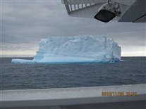
IMG_0641.jpg
Icebergs
I would have captioned these "Iceberg Alley" except we started seeing the long before entering the Antarctic Strait, which (as I understand it) is the "real" "Iceberg Alley).
Look closely at the"toe" at the left hand side of the iceberg in this photo. The next photo is a zoom-lens (and cropped) shot of penguins who were riding this iceberg at that location. We passed several icebergs with groups of penguins riding them.
(29 Nov 2010)
That "toe" is pointing in the direction this iceberg was drifting.
Shutter Speed : 1/1243.34
Date Time : 2010:11:28 10:01:42�
Equip Model : Canon PowerShot A495�
ISO Speed : ISO-80
Focal Length : 8.06
Aperture : F/3.18
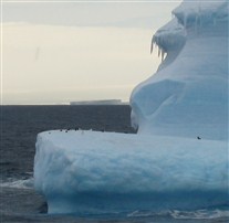
IMG_0644A.jpg
Penguins Riding an Iceberg
(29 Nov 2010)
Shutter Speed : 1/501.46
Date Time : 2010:11:28 10:02:44�
Equip Model : Canon PowerShot A495�
ISO Speed : ISO-80
Focal Length : 21.6
Aperture : F/5.78

S-IMG_1728.jpg
Penguins Riding an Iceberg
I believe this is actually a different iceberg. Notice the second iceberg in the background, and (also) in the far distance, at the left hand side, I believe that is a third iceberg.
(29 Nov 2010)


S-IMG_1815.jpg
And Another Set of Penguin Riders
I believe these are three separte icebergs.
(29 Nov 2010)


IMG_0650.jpg
Icebergs
I remember this day as being sunny -- parts of it were anyhow. I wonder if (for some strange reason) I took all the photos during the portion of the day that was overcast.
(29 Nov 2010)
Shutter Speed : 1/1002.93
Date Time : 2010:11:28 12:29:32�
Equip Model : Canon PowerShot A495�
ISO Speed : ISO-80
Focal Length : 12.05
Aperture : F/4
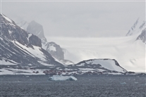
S-IMG_1888.jpg
Research Station (on shore)
The cluster of buildings along the shoreline (some of them just above the iceberg in the photo) is, I THINK, an Angentiene research base (and perhaps their largest one). This might be the place marked on the previous map as the Esperanza Base (apparenlty called Base Esperanza in Spanish).
Before going on this tirp, I envisioned as Antarctic "base" would have several hundred people working on it (similar to a US military post). However, I'm guessing perhaps 8 or 9 might be more typical. If this is, indeed, Esperanza Base, its population is around 50 during winter (with perhaps a peak of two or three times that in winter, not counting when a small cruise ship might do a landing there).
(29 Nov 2010)

IMG_0675A.jpg
Brown Bluff
Brown Bluff. Taken from the ship. Note the small boats. There is a small boat in the next photo too.
(29 Nov 2010)
Shutter Speed : 1/809
Date Time : 2010:11:28 17:24:15�
Equip Model : Canon PowerShot A495�
ISO Speed : ISO-160
Focal Length : 9.84
Aperture : F/5.6

IMG_0672.jpg
Brown Bluff
Brown Bluff. This was our second landing on the Antarctic Mainland. I think they tried hard to get the earlier one in because sometimes it is not possible to get to this place because of icebergs drifting close to shore. It's right on the Antarctic Strait.
Also, this location is susceptaible to what they call katabatic winds, which can also prevent landiings here. I didn't fully understand them, but my impressions was they were high winds caused (at least in part) by cold dense air flowing down step slopes (partly by gravity) from the glacier or icecap farther inland.
Air density decreases with altitude, but it increases as temperature gets lower (colder). I suspect what is happening is that the temperature is so low up on the high-altitude plateau on the Antarctic Pennisula that the effect of low temperature on air density overwhelms the effect of high altitude. If this is the case, the cold, high-altitude air is more dense than the warmer, low-altitude air below it. This (if my reasoning is correct), causes the cold, high altitude air to roll down the mountains to the low-altitude (coastal) areas. Hence, the katabatic wind. Despite what I've written in this paragraph, I have trouble visualizing this. I don't claim what I've written here is correct -- and, even if it is correct, I don't claim to fully understand it.
It's probably pretty clear where the name Brown Bluff comes from.
(29 Nov 2010)
Shutter Speed : 1/634.73
Date Time : 2010:11:28 17:23:50�
Equip Model : Canon PowerShot A495�
ISO Speed : ISO-160
Focal Length : 21.6
Aperture : F/5.78

IMG_1918.jpg
Fram with Iceberg Alley in the Background
Brown Bluff.
(29 Nov 2010)
Shutter Speed : 1/634.73
Date Time : 2010:11:29 16:27:38�
Equip Model : Canon PowerShot S1 IS�
Focal Length : 19.53
Aperture : F/4.5

IMG_1927A.jpg
Gentoo Penguins
Brown Bluff. These are probably sitting on eggs. I saw no babies here.
This location was probably close to 250 miles north of Petermann Island and Port Lockroy, where penguins were mating and building nests. I'm guessing the snow cover had vanished a few weeks earlier here, so the nest building and mating began earlier here.
(29 Nov 2010)
Shutter Speed : 1/634.73
Date Time : 2010:11:29 16:37:27�
Equip Model : Canon PowerShot S1 IS�
Focal Length : 58
Aperture : F/4.5
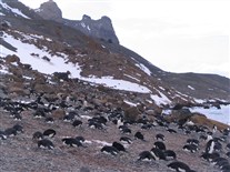
IMG_1946.jpg
Penguins.
Brown Bluff. It's pretty much penguins as far as the eye can see.
(29 Nov 2010)
Shutter Speed : 1/634.73
Date Time : 2010:11:29 16:46:30�
Equip Model : Canon PowerShot S1 IS�
Focal Length : 15.34
Aperture : F/4.5

IMG_1945A.jpg
Adelie Penguins
Brown Bluff. Apparently, the proper spelling of Adelie includes an accent mark over the first "e".
(29 Nov 2010)
Shutter Speed : 1/809
Date Time : 2010:11:29 16:44:59�
Equip Model : Canon PowerShot S1 IS�
Focal Length : 56.58
Aperture : F/4.5

A-capture_101001.jpg
Adelie Penguin
Probably Brown Bluff. They have kind of a blue ring around their eyes.
(29 Nov 2010)

IMG_1953A.jpg
Looking Approximately Westward from Brown Bluff
Note the impressive peak, the floating ice, and the penguins on the offshore rock.
(29 Nov 2010)
Shutter Speed : 1/1002.93
Date Time : 2010:11:29 16:50:15�
Equip Model : Canon PowerShot S1 IS�
Focal Length : 47.08
Aperture : F/5.03

IMG_1957A.jpg
Adelie Penguins
Brown Bluff.
(29 Nov 2010)
Shutter Speed : 1/634.73
Date Time : 2010:11:29 16:54:28�
Equip Model : Canon PowerShot S1 IS�
Focal Length : 26
Aperture : F/4.5


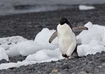
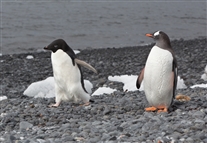
S-IMG_2058.jpg
An Adelie and a Gentoo
Brown Bluff. I can't recall if the Gentoo's also had a rookery here, or if this Gentoo was just visiting.
(29 Nov 2010)

S-IMG_2276.jpg
"Flying" Adele Penguin
Brown Bluff. They can't really fly. I'm not sure what was going on here.
(29 Nov 2010)

L-DSCF0381.jpg
Star of the Show
Brown Bluff.
At first glance, itt might look like tourists outnumber penguins here, but look in the background, especially on the right hand side. Also not the length of shadows. This was perhaps 7:30 pm-ish (if we had been operating on local sun time), but the sun never got very high in the sky here.
(29 Nov 2010)
Shutter Speed : 1/284.05
Date Time : 2010:11:29 16:30:17�
Equip Model : FinePix F80EXR�
ISO Speed : ISO-200
Focal Length : 5
Aperture : F/8.88

L-DSCF0369A.jpg
Study in Black and White -- and Blue and Brown and Orange
Brown Bluff. You can't tell from the quality of the end product, but a lot of work went into setting up this photo. There had to be a penguin in the background.
(29 Nov 2010)
Shutter Speed : 1/675.59
Date Time : 2010:11:29 16:09:10�
Equip Model : FinePix F80EXR�
ISO Speed : ISO-400
Focal Length : 11.9
Aperture : F/5.1

A-14-Cruise-10-001.jpg
Brown Bluff to Turret Point and Back to Drake Passage
This final map shows our course as we left Brown Bluff. We next went to Turret Point, which is on the east end of King George Bay on the south shoreline of King George Island (one of the South Shetlands). After landing there, we, went back thru the Nelson Starit, going back the toward Ushuaia, the reverse of the way we came. I just realized that I've throwing out the place names like I might know what I'm talking about. I don't. I had never heard of ANY of these places (other than Antarcitca, itself) prior to this trip.

A-IMG_0147.jpg
Coming Ashore at Turret Point
Turret Point. Notice how rocky the beach is. They had a sort of portable step-stool placed in the water in the front of the boat so (usually) you did not have to jump down onto the beach. The sea was pretty smooth when this photo was taken. Later, the waves began coming in pretty good. The waves were high enought so boats would be un-beached by each wave. People had to enter and leave the boats sort of between waves.
This may have been one of the places we would not have been permitted to land at if there had been more than 200 passengers able to go ashore.
This was a wet landing. When the waves picked up later, it became a very wet landing for some people.
(30 Nov 2010)

V-IMG_5084.jpg
Onshore Briefing
Turret Point. I belive this is Karin giving a briefing just as we came on shore. I'm the centermost of the blue jackets.
I'm not sure anyone defined the difference between a lecture and a briefing On the ship, I thought of briefings as times where they described a certain place or certain type of animal or bird, to try to help us understand some specifc thing we would see in the next day or so. Lectures were about more general topics, such as geology, or the Antarctic Treaty, or the history of how sled dogs had been used in the Antarctic (and the one about sled dogs was, to me, perhaps the most interesting of all of them).
Briefings would touch on any special hazards in an area. In most instances, there would also be a very short breifing once on shore. This was because (for example) often the expedition team would not know in advance about what specific animals would be present (or their specific locations). Also, they sometimes would not know the exact landing location in advance. For example, the shape of beaches can change from year to year.
(30 Nov 2010)
Shutter Speed : 1/501.46
Date Time : 2010:11:30 05:57:34�
Equip Model : Canon PowerShot S3 IS�
Focal Length : 6
Aperture : F/4

A-capture_101534.jpg
Chinstrap Penguin
Turret Point. There seemed to be one lone Chinstrap Penguin here.
(30 Nov 2010)

IMG_2003A.JPG.jpg
Probably Southern Giant Petrels
Turret Point.
I believe these are Southern Giant Pretels. There were lots of nests in these rocks (and in another even larger group or rocks). This was the only nesting area we saw for these birds. We were told to stay at least 50 or 60 feet away from them. They do a good job or hiding their nests within the rocks. There are a lot more nesting birds here than the ones visible in these photos. I don't have any photos here of the even large set of rocks because the birds there were even more effectively hidden. I could see a tiny portion of bird's body visible here and there among those larger rocks.
(30 Nov 2010)
Shutter Speed : 1/1002.93
Date Time : 2010:11:30 08:44:06�
Equip Model : Canon PowerShot S1 IS�
Focal Length : 17.98
Aperture : F/6.3

IMG_2003B.jpg
Probably Southern Giant Petrels
Turret Point. Cropped from the previous photo, I'm pretty sure.
(30 Nov 2010)
Shutter Speed : 1/1002.93
Date Time : 2010:11:30 08:44:06�
Equip Model : Canon PowerShot S1 IS�
Focal Length : 17.98
Aperture : F/6.3

IMG_1999A.jpg
Carl with (Probably) Southern Giant Petrels (in the background)
Turret Point.
The body of water behind me is probably King George Bay and the land behind is probably part of the north or west shore of King George Bay.
(30 Nov 2010)
Shutter Speed : 1/1243.34
Date Time : 2010:11:30 08:43:12�
Equip Model : Canon PowerShot S1 IS�
Focal Length : 5.97
Aperture : F/6.3

IMG_1999B.jpg
Carl on Turret Point
Turrett Point. Cropped from the previos photo.
In late 1969, I was one of a group of people who spent a week skiing and taking ski lessons at a place called VIlla bel View, near Mont Treblant, Quebec.
The ski instructors there were all either French of French Canadian (with one possible exception, who might have been Canadian, but not French). They all wore these "Canada Hats," white knit caps with a Maple Leaf insignia on them. Turns out, it has alwsys been difficult for me to ensure the insignia is is directly centered on my forehead when I put on the cap, so I usually look dorky in the hat (as is the case here). I hadn't worn the hat in years (perhaps decades), until I found it while preparing for this trip (we don't get much chance to wear really cold-weather clothes in South Carolina). I'd forgotten about how it so often made me look dorky.
Interestingly, the ski instructors at Mont Trembleu ALWAYS wore their hats with the Maple Leaf dead center. I suspect whatever lack of grace and coordination I have that prevented me from becoming an expert parallel skiier (being able to parallel ski with my feet always together), also prevents me from being able to put on the hat correctly.
(30 Nov 2010)
Shutter Speed : 1/1243.34
Date Time : 2010:11:30 08:43:12�
Equip Model : Canon PowerShot S1 IS�
Focal Length : 5.97
Aperture : F/6.3
IMG_2022.jpg
Close-up of Beach Rocks
Turret Point. Walking at Turret Point required a bit of care. The beach was not sand, but was instead made of rounded loose rocks, shown here. These varried in size from perhaps the size of ping pong balls up to the size of bowling balls. They tended to shift around a bit (rock and roll, so to speak) as you walked across them. It required more care and effort than "normal walking" (not "a walk on the beach" even though it WAS a walk on the beach).
(30 Nov 2010)
Shutter Speed : 1/634.73
Date Time : 2010:11:30 09:03:11�
Equip Model : Canon PowerShot S1 IS�
Focal Length : 12.06
Aperture : F/4.5

IMG_1973A.jpg
Seals
Turret Point. I'm not sure what kind of seals these are. I SUSPECT they are Waddell Seals, but they might be Crabeater Seals.
There was a large group of them on the beach and in sort of a large pond (or perhaps a tidal pool) on the beach. Unfortunately, I did not seem to get a photo (or perhaps not a good one) of the pond (and the goodly number of seals in it).
(30 Nov 2010)
The expedition staff told us there were young male seals -- the equivalent of teenagers. There was a lot of vocalizing an fighting going oh. However, it was apparently not "serious" fighting at this point in their lives. The staff described it as "praciice" for when they are older and will have to fight for breeding rights (to a harem of female, I imagine).
It could be one of the expedition team called them elephant seals. However, they don't look like the photos of elephant seals that I saw on the internet (and in the guidebook I purchased for this trip) when I started doing searches to try to put captions on these photos.
Shutter Speed : 1/501.46
Date Time : 2010:11:30 08:12:58�
Equip Model : Canon PowerShot S1 IS�
Focal Length : 58
Aperture : F/4.5


A-capture_102450.jpg
Seal
Turret Point. I know. There are too many photos of seals here. However, I think they had very expressive faces.
(30 Nov 2010)


S-IMG_2902.jpg
Ship's Officers
This was at a special dinner on one of the last two nights of the cruise, while traversing the Drake Passage sailing northward.
(Possibly 30 Nov 2010)

IMG_0685.jpg
Food Item at the Special Dinner
Some of the vegetables that had been carved the night before were used as decorations here.
(30 Nov 2010)
Shutter Speed : 1/39.67
Date Time : 2010:11:29 16:11:09�
Equip Model : Canon PowerShot A495�
ISO Speed : ISO-400
Focal Length : 6.6
Aperture : F/2.99

IMG_0686.jpg
Wooden Penguin
I believe this decoration (and several others) were always around the buffet tables in the dining room.
(30 Nov 2010)
Shutter Speed : 1/25.28
Date Time : 2010:11:29 17:13:03�
Equip Model : Canon PowerShot A495�
ISO Speed : ISO-400
Focal Length : 9.84
Aperture : F/3.51
IMG_0701A.jpg
Sunset in the Drake Passage
This was taken at 7:47 pm EST, which would probably have been equivalent to 10:47 pm in this time zone (if the ship had been operating on the true local time; I believe we stayed on Ushuaia time during the entire trip).
The temperatures were surprisingly not-super-cold throughout the Antarctic portion of the trip. They were probably in the 20s F both day and night. I suspect this was because the nights were so short. The sun was not below the horizon long enough for the temperature to drop much during the "night".
There were a few days where it FELT really cold. However, that was more due to wind and blowing snow, rather than the temperature actually being a lot lower those days.
(1 Dec 2010)
Shutter Speed : 1/125.37
Date Time : 2010:11:30 19:47:14�
Equip Model : Canon PowerShot A495�
ISO Speed : ISO-250
Focal Length : 21.6
Aperture : F/5.78

IMG_0712.jpg
Trivia Quiz Night
They also had a charity auction and this goofy trivia quiz one of the last two nights, while in the Drake Passage.
The trivia quiz seemed to be based soley on information from the relatively few cases where essentially the same lecture had been given in both German and English. I'm not sure, but it seemed people who did not speak one of these two languages were shut out of the quiz (but maybe there was a separate event for other languages).
It clear that some lectures were given in multiple languages. Occasionally a lecturer had slides which were labled in a language other than English.
(2 Dec 2010)
Shutter Speed : 1/25.28
Date Time : 2010:12:01 20:30:59�
Equip Model : Canon PowerShot A495�
ISO Speed : ISO-400
Focal Length : 8.06
Aperture : F/3.18

IMG_0713.jpg
Trivia Quiz Night
Most of these people were Vantage travelers.
(2 Dec 2010)
Shutter Speed : 1/19.84
Date Time : 2010:12:01 20:31:27�
Equip Model : Canon PowerShot A495�
ISO Speed : ISO-640
Focal Length : 6.6
Aperture : F/2.99

IMG_0714.jpg
Trivia Quiz Night
Most of these people were Vantage travelers.
(2 Dec 2010)
Shutter Speed : 1/15.03
Date Time : 2010:12:01 20:31:36�
Equip Model : Canon PowerShot A495�
ISO Speed : ISO-800
Focal Length : 6.6
Aperture : F/2.99

IMG_0715.jpg
Trivia Quiz Night
Most of these people were Vantage travelers.
(2 Dec 2010)
Shutter Speed : 1/19.84
Date Time : 2010:12:01 20:31:48�
Equip Model : Canon PowerShot A495�
ISO Speed : ISO-800
Focal Length : 6.6
Aperture : F/2.99

IMG_0718B.jpg
Trivia Quiz Night
Most of these people were Vantage travelers.
(2 Dec 2010)
Shutter Speed : 1/19.84
Date Time : 2010:12:01 20:32:26�
Equip Model : Canon PowerShot A495�
ISO Speed : ISO-400
Focal Length : 6.6
Aperture : F/2.99

IMG_0720.jpg
Back at the Dock in Ushuaia
Looking out the cabin's balcony. There seemed to be only one dock in Ushuaia. It handled both passenger ships and freighters.
(3 Dec 2010)
Shutter Speed : 1/809
Date Time : 2010:12:02 04:05:47�
Equip Model : Canon PowerShot A495�
ISO Speed : ISO-160
Focal Length : 6.6
Aperture : F/2.99

IMG_0721.jpg
Back at the Dock in Ushuaia
There seemed to have been snow at higher altitudes during the previous night. The 4:05 AM is EST. It was probably 6:05 AM local time.
(3 Dec 2010)
Shutter Speed : 1/158.68
Date Time : 2010:12:02 04:05:59�
Equip Model : Canon PowerShot A495�
ISO Speed : ISO-80
Focal Length : 12.05
Aperture : F/4

IMG_0731.jpg
Waiting to Leave the Ship
We were at the dock in Ushuaia. There was a delay in leaving the ship because of ..... well, I never understood why there was a delay. However, while we were sitting around, I realized that I did not have many photos of the interior ot the ship.
(3 Dec 2010)
Shutter Speed : 1/50.56
Date Time : 2010:12:02 05:26:18�
Equip Model : Canon PowerShot A495�
ISO Speed : ISO-400
Focal Length : 6.6
Aperture : F/2.99

IMG_0730.jpg
MS Fram -- Interiors
As indicated earlier, realized I did not have photos of several areas of the interior of the ship. This is a fake fireplace in an area of Deck 4 they call the lobby. It's a video display with a "movie" of a fire (moving flames -- but no heat).
Shutter Speed : 1/39.67
Date Time : 2010:12:02 05:04:16�
Equip Model : Canon PowerShot A495�
ISO Speed : ISO-400
Focal Length : 6.6
Aperture : F/2.99

IMG_0733.jpg
MS Fram -- Interiors
Another part of the lobby. Those are bulliten boards for ship information on the left hand side. The door at right leads to one of the classrooms or meeting rooms where lectures and briefiings were held.
Shutter Speed : 1/39.67
Date Time : 2010:12:02 05:26:57�
Equip Model : Canon PowerShot A495�
ISO Speed : ISO-400
Focal Length : 6.6
Aperture : F/2.99

IMG_0732.jpg
MS Fram -- Interiors
This is their Internet area. We had Internet access the whole trip (at extra cost). I didn't think to ask, and I haven't tried to visualize the geometry, but my guess it that it was through the "geostationary" communicaition satellites above the equator. I imagine they were always above the horizon at the latitudes we were at.
Shutter Speed : 1/19.84
Date Time : 2010:12:02 05:26:50�
Equip Model : Canon PowerShot A495�
ISO Speed : ISO-640
Focal Length : 6.6
Aperture : F/2.99

IMG_0735.jpg
MS Fram -- Interiors
The Bistro. There is al little shop behind me that had coffee and tea available (compelemtary, if I recall correctly). Hot chocolate, pastries, and cookies cost extra.
Shutter Speed : 1/39.67
Date Time : 2010:12:02 05:27:29�
Equip Model : Canon PowerShot A495�
ISO Speed : ISO-400
Focal Length : 6.6
Aperture : F/2.99

IMG_0736.jpg
MS Fram -- Interiors
In the Bistro looking the opposite direction. The counter is for the coffee, hot chocolate, tea, etc. The door to the left of it is to the ship's store (which was closed when this was taken). It sold gifts, toothpaste, and some clothing (like the cool cable-knit sweater I did not have luggage space to take home with me.
Shutter Speed : 1/39.67
Date Time : 2010:12:02 05:27:41�
Equip Model : Canon PowerShot A495�
ISO Speed : ISO-400
Focal Length : 6.6
Aperture : F/2.99

IMG_0741.jpg
MS Fram -- Interiors
This is the foreward observation lounge (and bar) up on Deck 7.
Shutter Speed : 1/79.34
Date Time : 2010:12:02 05:30:12�
Equip Model : Canon PowerShot A495�
ISO Speed : ISO-125
Focal Length : 8.06
Aperture : F/3.18

IMG_0748.jpg
MS Fram -- Interiors
This is the foreward observation lounge (and bar) up on Deck 7. The silver thing in the background was kind of a security gate they could pull down when the bar was closed
Shutter Speed : 1/60.13
Date Time : 2010:12:02 05:31:48�
Equip Model : Canon PowerShot A495�
ISO Speed : ISO-400
Focal Length : 6.6
Aperture : F/2.99

IMG_0745.jpg
MS Fram -- Interiors
These really cool seats faced the foreward (the direction of travel).
Shutter Speed : 1/79.34
Date Time : 2010:12:02 05:31:10�
Equip Model : Canon PowerShot A495�
ISO Speed : ISO-160
Focal Length : 8.06
Aperture : F/3.18

IMG_0749.jpg
MS Fram -- Interiors
Bar area in Deck 7 lounge. The dance floor is visible at right and a piano and some microphones are behind it. I believe there had been one night in Chile when a local band came on board and provided entertainment.
Shutter Speed : 1/50.56
Date Time : 2010:12:02 05:31:57�
Equip Model : Canon PowerShot A495�
ISO Speed : ISO-640
Focal Length : 6.6
Aperture : F/2.99

IMG_4937.jpg
Vantage Group Photo
This is placed here out of sequence. I'm using it here to mark the end of photos taken while on the cruise portion of the trip.
I'm in the white had in the back toward the left hand side.

IMG_0780.jpg
On Land in Ushuaia
Immediately after leaving the ship. We had several free hours in Ushauia prior to an early afternoon flight to Buenos Aires.
(3 Dec 2010)
Shutter Speed : 1/634.73
Date Time : 2010:12:02 09:44:21�
Equip Model : Canon PowerShot A495�
ISO Speed : ISO-160
Focal Length : 6.6
Aperture : F/4.5

IMG_0752A.jpg
MS Fram at Ushuaia
This was taken from near that Ushuaia sign. This photo was used earlier in the album.
(3 Dec 2010)
Shutter Speed : 1/317.37
Date Time : 2010:12:02 07:03:38�
Equip Model : Canon PowerShot A495�
ISO Speed : ISO-80
Focal Length : 17.55
Aperture : F/5.03

IMG_0756.jpg
Looking East Along the Waterfront in Ushuaia
I believe the ship in the distance is either at a fuel offload station or else a navy facility (or perhaps both).
(3 Dec 2010)
Shutter Speed : 1/1243.34
Date Time : 2010:12:02 07:04:57�
Equip Model : Canon PowerShot A495�
ISO Speed : ISO-160
Focal Length : 9.84
Aperture : F/3.51

IMG_0757.jpg
Ushuaia
(3 Dec 2010)
Shutter Speed : 1/404.5
Date Time : 2010:12:02 07:05:05�
Equip Model : Canon PowerShot A495�
ISO Speed : ISO-125
Focal Length : 21.6
Aperture : F/5.78

IMG_0776.jpg
Ushuaia Museum
Ushaia was the site of a large prison for many years (it wasn't clear, but the prison might have been there before the town). This prison is now a museum. As the sign indicates, there are, in a sense, several museums in the building. However, there is only one ticket to see whatever part you wish (or all of it). I thought of this as a single museum. despite this sign.
Visited two other (smaller) interesting museums in town, but I apparently took photos only at this one.
(3 Dec 2010)
Shutter Speed : 1/634.73
Date Time : 2010:12:02 08:30:46�
Equip Model : Canon PowerShot A495�
ISO Speed : ISO-125
Focal Length : 9.84
Aperture : F/3.51

IMG_0760.jpg
Ushuaia Museum
They had excellent wooden scale models of several Spanish exploration ships. This is one of Magellan's. Unfortunately, most of the models were in glass cases, so they were difficult to photograph due to reflections off the glass.
They had models of ships used by several Spanish explorers I had never heard of. Apparently, we learn only brief highlights of the history or other countries.
(3 Dec 2010)
Shutter Speed : 1/30.06
Date Time : 2010:12:02 07:30:19�
Equip Model : Canon PowerShot A495�
ISO Speed : ISO-400
Focal Length : 6.6
Aperture : F/2.99

IMG_0764.jpg
Ushuaia Museum
This is a model of the Beagle, the ship Charles Darwin served on for about 5 years. It was a British ship, not Spanish, but the ARE on the Beagle Channel.
Argentina seemed very cool toward Britain due to the 1982 war. However, that did not seem to apply to Darwin and to the Beagle.
(3 Dec 2010)
Shutter Speed : 1/30.06
Date Time : 2010:12:02 07:38:19�
Equip Model : Canon PowerShot A495�
ISO Speed : ISO-400
Focal Length : 6.6
Aperture : F/2.99

IMG_0765.jpg
Ushuaia Museum
Several exhibits illustrated the history of the prison and conditions in the prison. If I recall correctly, the prison dates from the 1890s (and closed -- with much of the land and some of the buildings to be converted to a navy base -- in the late 1940s).
I was surprised to see it looked like a US penitentiary. I would have thought that, in the 1890s, there would be little need for high security since, if someone escaped, there would be no place to go. (t's a very remote area.
(3 Dec 2010)
Shutter Speed : 1/19.84
Date Time : 2010:12:02 07:42:39�
Equip Model : Canon PowerShot A495�
ISO Speed : ISO-500
Focal Length : 6.6
Aperture : F/2.99

IMG_0772.jpg
Ushuaia Museum
The original prison building had five long cell blocks, coming out from a central guard station like spokes on a wheel. The five museums are (roughly in, if I recall correctly, three of the wings (some of the five museums are not large enough to fill an entire wing). One wing is (again, if I recall correctly) not currently in good enough condition to be used. The fifth wing was left pretty much as it was in prison days. This is a photo of that wing, with most of the cell doors open.
(3 Dec 2010)
The thing in the center of the corridor is a wood stove. There were apparenlty two such stoves per wing to heat the cell blocks during winter.
The cell blocks were two levels high. The linear features extending from the upper corners of the photo are the underside of the walkways that provide access to the upper rows of cells.
Shutter Speed : 1/25.28
Date Time : 2010:12:02 08:13:03�
Equip Model : Canon PowerShot A495�
ISO Speed : ISO-400
Focal Length : 6.6
Aperture : F/2.99

IMG_0766A.jpg
Ushuaia Museum
The prison museum cat, who it turns out, is famous. The seatback magazine on the airline flight back to Buenos Aires had an article about thiis museum (and other places in Ushuaia). The article featured a photo of this cat.
(3 Dec 2010)
Shutter Speed : 1/19.84
Date Time : 2010:12:02 07:47:42�
Equip Model : Canon PowerShot A495�
ISO Speed : ISO-400
Focal Length : 6.6
Aperture : F/2.99

L-DSCF0424.jpg
Prison Cat -- Again
Here the cat is next to a heater in one of the cell blocks now used as a museum. It looks like the heater was originally fueled with wood or coal, but has now been converted to use natural gas (or, perhaps more likely, propane -- given that almost everything used in Ushuaia comes in by ship). It looks as if a safety barrier has also been placed around the heater.
The heater/stove in an earlier photo (in the cell block left in prison-days conditon) had not been modfiied, but that cell block was not heated.
(3 Dec 2010)
Shutter Speed : 1/23.1
Date Time : 2010:12:03 07:47:15�
Equip Model : FinePix F80EXR�
ISO Speed : ISO-1600
Focal Length : 11.9
Aperture : F/5.1

IMG_0773.jpg
Ushuaia Museum
In the naural history part of the museum. There are the 17 or 18 different kinds of penguins, with their names in Spanish.
We saw only four: Magellanic, Chinstrap, Gentoo, and Adele. Two others who live in Antarctica, King Penguin and Emperor Penguin, either nest farther south than we were, or else nest farther inland (or maybe both). They are the two largest penguins. I believe we were told at a briefing there was a slight chance we might see a few of these swimming in the ocean, but would not see any of their rookeries. I'm not aware that anyone on our cruise saw either type.
(3 Dec 2010)
Shutter Speed : 1/60.13
Date Time : 2010:12:02 08:24:38�
Equip Model : Canon PowerShot A495�
ISO Speed : ISO-200
Focal Length : 6.6
Aperture : F/2.99

IMG_0781.jpg
Ushuaia
This was the sign on a tourist bus parked next to ours. It seemed amusing because polar bears live only in the Arctic, not the Antarctic.
(3 Dec 2010)
Shutter Speed : 1/101.13
Date Time : 2010:12:02 09:51:46�
Equip Model : Canon PowerShot A495�
ISO Speed : ISO-160
Focal Length : 14.8
Aperture : F/4.5

IMG_0786.jpg
Buenos Aires
This is the next morning, after we had flown on LAN toBuenos Aires. South American airlines are sort of like US Airlines were 30 years ago -- a hot meal (or at least a box lunch) on every flight, no matter how short it is.
Valerie (and her mother, who also works for Vantage) had a "help desk" set up in the hotel lobby.
(4 Dec 2010)
Shutter Speed : 1/50.56
Date Time : 2010:12:03 06:56:15�
Equip Model : Canon PowerShot A495�
ISO Speed : ISO-640
Focal Length : 8.06
Aperture : F/3.18

IMG_0787.jpg
Buenos Aires
It seemed like a good chance to take more people photos-- these are people in the Vantage group (mostly). This is in the hotel lobby.
(4 Dec 2010)
Shutter Speed : 1/50.56
Date Time : 2010:12:03 06:56:35�
Equip Model : Canon PowerShot A495�
ISO Speed : ISO-640
Focal Length : 6.6
Aperture : F/2.99
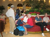
IMG_0788.jpg
Buenos Aires
It seemed like a good chance to take more people photos-- these are people in the Vantage group (mostly).
(4 Dec 2010)
Shutter Speed : 1/50.56
Date Time : 2010:12:03 06:56:53�
Equip Model : Canon PowerShot A495�
ISO Speed : ISO-640
Focal Length : 6.6
Aperture : F/2.99
IMG_0798.jpg
Buenos Aires
We had a tour of a part of the city not previously seen on this last day. Some interesting flowers.
(4 Dec 2010)
Shutter Speed : 1/125.37
Date Time : 2010:12:03 08:10:08�
Equip Model : Canon PowerShot A495�
ISO Speed : ISO-320
Focal Length : 21.6
Aperture : F/5.78

IMG_0806.jpg
Buenos Aires
This was an area where tour boats of various kinds cruise around in a network of rivers (kind of a river delta area, and, if I recall correctly, "delta" is the term they used.
(4 Dec 2010)
Shutter Speed : 1/1243.34
Date Time : 2010:12:03 08:55:35�
Equip Model : Canon PowerShot A495�
ISO Speed : ISO-160
Focal Length : 8.06
Aperture : F/3.18

IMG_0808.jpg
Buenos Aires
Several rowing clubs had boat houses in this area. I had the impression a lot of wealthy immigrant communities lived in this area (having settled in Argentina in the first half of the 1900s). There seemed to be things schools where courses were taught in French, English, German, etc., in addition to these rowing clubs, several of which were also associated with nationality groups.
(4 Dec 2010)
Shutter Speed : 1/125.37
Date Time : 2010:12:03 09:02:47�
Equip Model : Canon PowerShot A495�
ISO Speed : ISO-80
Focal Length : 21.6
Aperture : F/5.78

IMG_0811.jpg
Buenos Aires
I believe this is a boat club. Or perhaps the story was that it had once been one, and is now a restaurant.
(4 Dec 2010)
Shutter Speed : 1/1002.93
Date Time : 2010:12:03 09:07:29�
Equip Model : Canon PowerShot A495�
ISO Speed : ISO-80
Focal Length : 8.06
Aperture : F/3.18

IMG_0799.jpg
Buenos Aires
We had a tour of a part of the city not previously seen on this last day. Some interesting flowers
My memory of this day was of kind of going through the motions. I'd DONE Antarctica (the REAL purpose of the trip). This stuff was OK, but pretty mundane compared to Antarctica.
(4 Dec 2010)
Shutter Speed : 1/101.13
Date Time : 2010:12:03 08:11:30�
Equip Model : Canon PowerShot A495�
ISO Speed : ISO-160
Focal Length : 14.8
Aperture : F/4.5

IMG_0815A.jpg
Buenos Aires
This is an area where all of the homes have river frontage (and private docks -- it seemed like a well-to-do area). Because of the way the rivers cut across the land, for many of these home, it is more convenient to access the home by boat than by streets. This is a floating grocery store (a water-borne peddler). If the homeowner wants the "store" boat to stop, they have a way of signaling by hanging something off the end of their private dock.
We saw several family dogs (watchdogs?) laying on the docks for individual homes, just watching boats go by.
(4 Dec 2010)
Shutter Speed : 1/501.46
Date Time : 2010:12:03 09:36:38�
Equip Model : Canon PowerShot A495�
ISO Speed : ISO-160
Focal Length : 6.6
Aperture : F/2.99

IMG_0818A.jpg
Buenos Aires
Just seemed to be a cool-looking bird next to a jackaranda tree.
(4 Dec 2010)
Shutter Speed : 1/317.37
Date Time : 2010:12:03 09:56:46�
Equip Model : Canon PowerShot A495�
ISO Speed : ISO-400
Focal Length : 21.6
Aperture : F/5.78

IMG_0820.jpg
Buenos Aires
More flowers.
(4 Dec 2010)
Shutter Speed : 1/317.37
Date Time : 2010:12:03 12:23:27�
Equip Model : Canon PowerShot A495�
ISO Speed : ISO-160
Focal Length : 6.6
Aperture : F/2.99

IMG_0821.jpg
Buenos Aires
Another flower.
(4 Dec 2010)
Shutter Speed : 1/125.37
Date Time : 2010:12:03 12:23:34�
Equip Model : Canon PowerShot A495�
ISO Speed : ISO-160
Focal Length : 21.6
Aperture : F/5.78

IMG_0823.jpg
Buenos Aires
This is a restaurant where we had lunch on this city tour. The place had a wall around it, with only a narrow entrance gate. It was difficult to get any place far enough to get an unobstructed photo of the building. I believe I was standing in the entrance gateway to take this.
(4 Dec 2010)
Shutter Speed : 1/634.73
Date Time : 2010:12:03 12:23:59�
Equip Model : Canon PowerShot A495�
ISO Speed : ISO-160
Focal Length : 6.6
Aperture : F/2.99

IMG_0826.jpg
Buenos Aires
I can't recall if I took this photo to have something representing a typical house in this area, or if there was something special about it. Perhaps someone who was on the tour can contact me if they remember.
(4 Dec 2010)
Shutter Speed : 1/809
Date Time : 2010:12:03 12:37:21�
Equip Model : Canon PowerShot A495�
ISO Speed : ISO-80
Focal Length : 6.6
Aperture : F/2.99
